Results 1 to 5 of 5

Thread: WIP- Iltoir (Regional detailed map)

Hybrid View

Previous Post Previous Post   Next Post Next Post
  1. #1

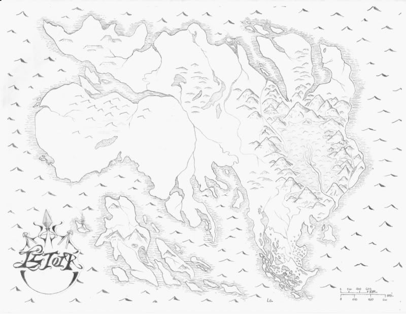
    Map WIP- Iltoir (Regional detailed map)

    Save for the names, this map is almost entirely finished. I would love any and all feedback about it, I worked quit hard for a while on this one, I intend to put it into my book should I ever publish.


    The lands far to the west under the small sea is a desert. The land above that is barren plateaus and a frigid northern coast. The area within the mountains is tropical rainforest. The central land is hills and grasslands. The islands are a volcanic archipelago. beneath the mountains lies the marshes.
    Last edited by Avyra; 05-26-2010 at 06:05 PM.

  2. #2

    Default

    That's a gorgeous pencil map!

    Aesthetically, the about the only hard and fast change I'd recommend is with the capital letter I in your title - it looks way too similar to the letter L - and the R's stem could use some thickening. As it is, I'm reading it as LLTOIP.

    Concerning the substance of the map itself, though, your central river systems need some attention if this is to be a world that's realistic. Typically, rivers will all form from smaller tributaries at a higher elevation into a single large river before exiting into the ocean, rather than joining and then splitting again. Also, a river won't flow from one ocean to another.

  3. #3

    Default

    Perhaps I should have specefied on the map, thank you, the river is not actually running from ocean to ocean, at the central point is a very large spring in a solitary mountain, I'm glad you pointed it out however because I did indeed forget to draw the mountan :X hehe thus the WIP. thanks for the tips, I struggle sometimes with the reality though its very important to me. X)

  4. #4
    Community Leader Facebook Connected Ascension's Avatar
    Join Date
    Jun 2008
    Location
    St. Charles, Missouri, United States
    Posts
    8,392

    Default

    I completely agree with Imperial about the I and the R and that should be an easy fix. Instead of telling us what is what and where it is; those things should be labeled on the map so that it can be read. I'll also back Imperial on the rivers, naturally, because I'm on the River Police. Now I know that this is fantasy and you can do whatever you want but violating the laws of physics always rubs me wrong and there will be many who come after me saying this and that and that's it's ok. For what it's worth, here it goes: rivers don't split and stay split except for deltas (they are in such flat areas that the river courses change often and thus end up splitting and joining frequently over time). Instead, they join together. They split to go around harder rock or higher mounds but rejoin quickly. They don't go from ocean to ocean because that would require completely flat terrain and then the river would be saltwater due to the sea sloshing through. On the plus side, your rivers on the eastern 1/3 are perfect and your drawing style is very nice. You might want to ink it when done if it will get printed because pencil usually reproduces poorly.
    If the radiance of a thousand suns was to burst at once into the sky, that would be like the splendor of the Mighty One...I am become Death, the Shatterer of worlds.
    -J. Robert Oppenheimer (father of the atom bomb) alluding to The Bhagavad Gita (Chapter 11, Verse 32)


    My Maps ~ My Brushes ~ My Tutorials ~ My Challenge Maps

  5. #5
    Administrator Redrobes's Avatar
    Join Date
    Dec 2007
    Location
    England
    Posts
    7,245
    Blog Entries
    8

    Default

    Nice map theres lots to like about it. I'm not all that sure about the peaky wave things cos to me they looked a bit like mountains and I had to look several times to see whether I was looking at land or sea or whether the two were inverted. Maybe just keep the sea nice and simple. I would agree also with the rivers thing. Even if you have a big and magical spring in the middle of the landmass then there's a few other rivers joining between seas. Don't worry we get this a *lot* so much so we have river police now (look out for the badges like Ascensions). I'm not one so to try to help get you off the hook before they get mean and issue an arrest warrant, have a look over this tut.

    http://www.cartographersguild.com/sh...he-right-place

    Remember this is for real rivers - if your map uses other worldly effects then its fair game. Its your map.

Tags for this Thread

Posting Permissions

  • You may not post new threads
  • You may not post replies
  • You may not post attachments
  • You may not edit your posts
  •