Page 1 of 2 12 LastLast
Results 1 to 10 of 20

Thread: The known lands of Eoberath

Hybrid View

Previous Post Previous Post   Next Post Next Post
  1. #1
    Professional Artist ThomasR's Avatar
    Join Date
    Nov 2015
    Location
    Angers, France
    Posts
    4,180

    Map The known lands of Eoberath

    Hey guildfellows !

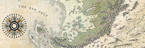
    Lately, I've been juggling with some hired works and a demanding 18 month old. Work has been going slowly but it's getting back to its usual pace, that's why I can show you this one. A world map for a private TTRPG party. It's a B&W map but its likely to get color in the next few month (as well as continental maps but it's not decided yet). It's been pretty fun to work on and I found peace in the curved hatchings shared by the compass rose and the title and the border. I think it contributes largely to the look of the map. It's one I'm pretty happy with. The labeling has been challenging as the client asked for minimum surface so that the names do not hide the map too much. In his words "it doesn't matter if I have to over-zoom it !" (slight paraphrase here but that's the spirit). The map is meant to be used on a screen and, having recently upgraded my setup from a Macbook Air 13" to a Macbook Pro 13" (mainly for RAM purpose), the Retina screen is scrambling my marks a little bit (that doesn't help for labels). I'd love to hear your thoughts on the map AND on the labeling.

    Here comes the map (at full scale thanks to the client).

    post.jpg

    © Thomas REY - 2018 - All rights reserved

    I hope you like it

  2. #2

    Default

    Wow, I do! That's a magnificent compass too. I'm always looking for smart ways to make the northern direction a little larger or more prominent.

    There's just a couple words, like the Gasping Spires, that are a little tricky to read in black and white. That might all go away with potential color, though. I sometimes put a white PS glow to varying opacity around letters, though it's a bit of a cop-out on my part and I'm not sure what a truly better solution would be to make them more legible on a map. I think that you've made the text as low-impact as the client could ever hope for.

    Edit: Ah, I can actually see the white stroke around them now haha

  3. #3
    Professional Artist ThomasR's Avatar
    Join Date
    Nov 2015
    Location
    Angers, France
    Posts
    4,180

    Default

    Quote Originally Posted by Compass Rose View Post
    Wow, I do! That's a magnificent compass too. I'm always looking for smart ways to make the northern direction a little larger or more prominent.

    There's just a couple words, like the Gasping Spires, that are a little tricky to read in black and white. That might all go away with potential color, though. I sometimes put a white PS glow to varying opacity around letters, though it's a bit of a cop-out on my part and I'm not sure what a truly better solution would be to make them more legible on a map. I think that you've made the text as low-impact as the client could ever hope for.

    Edit: Ah, I can actually see the white stroke around them now haha
    Thanks Rose The compass is a favorite of mine, I guess it's the third time I do this one (first by hand, then big and this one is the last). I'll do my best with the colored labels !

    Quote Originally Posted by Mouse View Post
    That's looking really great, Thomas

    I really like the font, but I can see what you mean about the scrambling of the marks. I hope you can find some kind of solution to that little problem for future maps, but I'm sure that you will.

    One of the main names keeps catching at my tired old brain by reminding me too much of a more familiar word. It's Gamarian, which is only two letters different to grammarian (as in old grammar school pupil). I expect that's only a mental jolt for English speaking people, though

    There is a legibility problem, but I expect that will resolve itself once you move onto the coloured version.
    Thanks Sue ! You might be onto something with Gamaria as it's populated by beastfolks and, as a man married to a litterature teacher, I can say grammarians are barbarians I hope you're right about the legibility but the client's happy and that's what counts (many labels means problems ahead, always).

    Quote Originally Posted by Voolf View Post
    Great map Thomas. The compass really does shine with that texture here.
    One thing... i am not fond of "overzoomed" labels, but i know it is hard to place them on B&W map and keep the legibility of both map and labels.
    Good job
    Thanks Rafal I know you love that texture. I even tried using it to shade the mountains but they were too small (I'm sure it could look cool). For the labels, I raised the same problem with the clients but he insisted.

    Quote Originally Posted by Ilanthar View Post
    As I previously said, I love the land shape on this, as well as your distinctive compass/frame combination (so well done!) .

    About the labels : I prefer continent names on the continents and maybe some smaller labels for the oceans. Apart from some mountains labels, they all seem to be legible without the full zoom "on" (at least for me, the myopic guy). Placements are fine, though I tend to limit to the max curved labels every time I can these days.

    Oh! And I love the size and effect of the title, of course !
    Merci Julien You are right, the compass/frame duo is becoming a thing in my maps, I gotta renew my techniques a bit. The continent names could have fit on the continents themselves but in black and white I did not want to hide the land features. %In color I can use a low opacity color to do it. And I try to avoid double curved labels but that crowding problem with the labels forced me to break that rule. And thanks for the title

    Quote Originally Posted by MistyBeee View Post
    A very great map : there is a lot of work here, isn't it ?
    It's the kind of map I can watch for hours : so many details to see, and stories to imagine !
    Merci Beee ! I think it's roughly a 20 hours map. The difficulty was to fit all I had to show in a 21x42 cm map (I worked at 400 % zoom with a retina screen !). The client asked me to add some adventure sparks in the terrains so, you telling me the map brings out stories means I did the job right

    Quote Originally Posted by LizardInk View Post
    This is a really fantastic map! It reminds me a little of Earthsea with all the islands.
    Thanks Jess That is a great compliment and I hadn't realized the islands gave this feeling. Thanks !

  4. #4

    Default

    Quote Originally Posted by ThomasR View Post
    For the labels, I raised the same problem with the clients but he insisted.
    I get it. We have to do what we have to do to please the client
    New Horizons
    Fantasy maps and illustrations.


    All my non-commisioned maps are FREE for personal use. Get them at my home page New Horizons
    Get more of my maps by becoming my Patreon.

    Support:
    Patreon | Tip via PayPal.Me | Buy Me a Coffee

  5. #5

    Default

    That's looking really great, Thomas

    I really like the font, but I can see what you mean about the scrambling of the marks. I hope you can find some kind of solution to that little problem for future maps, but I'm sure that you will.

    One of the main names keeps catching at my tired old brain by reminding me too much of a more familiar word. It's Gamarian, which is only two letters different to grammarian (as in old grammar school pupil). I expect that's only a mental jolt for English speaking people, though

    There is a legibility problem, but I expect that will resolve itself once you move onto the coloured version.

  6. #6

    Default

    Great map Thomas. The compass really does shine with that texture here.
    One thing... i am not fond of "overzoomed" labels, but i know it is hard to place them on B&W map and keep the legibility of both map and labels.
    Good job
    New Horizons
    Fantasy maps and illustrations.


    All my non-commisioned maps are FREE for personal use. Get them at my home page New Horizons
    Get more of my maps by becoming my Patreon.

    Support:
    Patreon | Tip via PayPal.Me | Buy Me a Coffee

  7. #7

    Default

    As I previously said, I love the land shape on this, as well as your distinctive compass/frame combination (so well done!) .

    About the labels : I prefer continent names on the continents and maybe some smaller labels for the oceans. Apart from some mountains labels, they all seem to be legible without the full zoom "on" (at least for me, the myopic guy). Placements are fine, though I tend to limit to the max curved labels every time I can these days.

    Oh! And I love the size and effect of the title, of course !

  8. #8

    Default

    A very great map : there is a lot of work here, isn't it ?
    It's the kind of map I can watch for hours : so many details to see, and stories to imagine !

  9. #9
    Guild Journeyer LizardInk's Avatar
    Join Date
    Apr 2018
    Location
    South Carolina, USA
    Posts
    216

    Default

    This is a really fantastic map! It reminds me a little of Earthsea with all the islands.

  10. #10
    Professional Artist ThomasR's Avatar
    Join Date
    Nov 2015
    Location
    Angers, France
    Posts
    4,180

    Map

    Hey fellows again,

    Let me share with you the political map :

    post2.jpg

    ... plus this labeling nightmare :

    The Beast.jpg

    It makes my eyes bleed, honest !

Page 1 of 2 12 LastLast

Tags for this Thread

Posting Permissions

  • You may not post new threads
  • You may not post replies
  • You may not post attachments
  • You may not edit your posts
  •