Results 1 to 10 of 11

Thread: Old map of mine in ms paint.

Hybrid View

Previous Post Previous Post   Next Post Next Post
  1. #1
    Guild Adept Aenigma's Avatar
    Join Date
    Aug 2009
    Location
    Visby, Gotland, Sweden
    Posts
    320

    Map Old map of mine in ms paint.

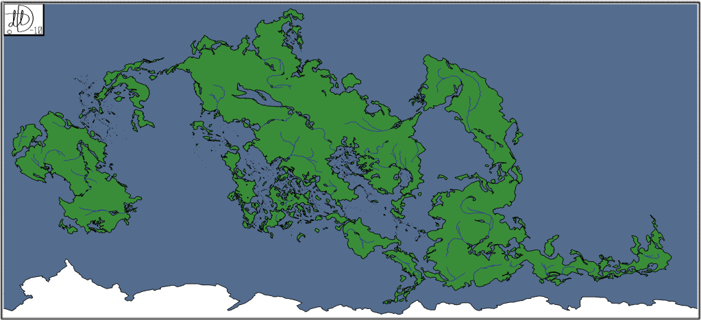
    So... I made this map in Ms Paint quite a while ago, and I just felt I should upload it here
    I uploaded it in a smaller size than the original since the original is 3 646px × 1 668px.

    I don't know where the deserts should be on this map.

    If you want to see it in its original size then you can do that here:
    http://s139.photobucket.com/albums/q...anetbig8-1.png
    Last edited by Aenigma; 04-29-2010 at 06:51 PM. Reason: Santa claus told me
    Yesterday today was tomorrow.
    My deviantart: http://darkaiz.deviantart.com/

  2. #2
    Community Leader Facebook Connected Steel General's Avatar
    Join Date
    Jun 2008
    Location
    Ft. Wayne, IN
    Posts
    9,531

    Default

    I'll say it again, anyone who manages anything at all in the abomination that is MS-Paint deserves a standing ovation.
    My Finished Maps | My Challenge Maps | Still poking around occasionally...

    Unless otherwise stated by me in the post, all work is licensed under a Creative Commons Attribution-Noncommercial 3.0 United States License.


  3. #3
    Guild Adept Yandor's Avatar
    Join Date
    Oct 2007
    Location
    Utah
    Posts
    360

    Default

    Quote Originally Posted by Steel General View Post
    I'll say it again, anyone who manages anything at all in the abomination that is MS-Paint deserves a standing ovation.
    haha amen, enough said!
    Projects
    WIP :: Carian Round... Who knows...

    Back Burner :: World Map

    Software: 99% Adobe Photoshop (CS4), Geo Control 2, Wilbur Every so often I use another program!

  4. #4
    Guild Member
    Join Date
    Apr 2009
    Location
    A Coruña, Galicia, Spain
    Posts
    93

    Default

    Whoa. And you did it in MS Paint? From scratch?

  5. #5
    Guild Adept Aenigma's Avatar
    Join Date
    Aug 2009
    Location
    Visby, Gotland, Sweden
    Posts
    320

    Default

    Quote Originally Posted by Steel General View Post
    I'll say it again, anyone who manages anything at all in the abomination that is MS-Paint deserves a standing ovation.
    Many thanks!

    Quote Originally Posted by silverhead View Post
    Whoa. And you did it in MS Paint? From scratch?
    Yes I did
    Yesterday today was tomorrow.
    My deviantart: http://darkaiz.deviantart.com/

  6. #6

    Default

    Quote Originally Posted by silverhead View Post
    Whoa. And you did it in MS Paint? From scratch?
    In MS Paint all you can do is scratch!

    Kudos for talent over tools!


    Dollhouse Syndrome = The temptation to turn a map into a picture, obscuring the goal of the image with the appeal of cute, or simply available, parts. Maps have clarity through simplification.

    --- Sigurd

  7. #7
    Guild Member Facebook Connected
    Join Date
    Apr 2010
    Location
    A, A
    Posts
    56

    Default

    Good job, especially considering that you were working with MS Ain't. As for where the deserts would be, think of it this way...

    Where are your tectonic plates; the plateaus on which your continents sit? Once you know where those are, you can place your mountains. Mountain commonly occur along a point where two tectonic plates meet. Deserts typically occur on the leeward side of mountains. The reason for this is because as the air is forced up the windward side of the mountains, it condenses into rain. By the time it crests the top, much of what is left is dry air. That's why it rains a lot in Seattle.
    John Grigsby
    Gaming Operations Director, CoastCon 37
    Member-at-Large, CoastCon 37

    Currently using Dundjinni, Photoshop CS3, and MapTool
    Unless otherwise stated, any work I post here can be freely used and distributed provided credit is given to me as the originator. If you find it useful or make modifications, I'd love to hear about it.

  8. #8
    Guild Adept Aenigma's Avatar
    Join Date
    Aug 2009
    Location
    Visby, Gotland, Sweden
    Posts
    320

    Default

    Quote Originally Posted by whtknt View Post
    Good job, especially considering that you were working with MS Ain't. As for where the deserts would be, think of it this way...

    Where are your tectonic plates; the plateaus on which your continents sit? Once you know where those are, you can place your mountains. Mountain commonly occur along a point where two tectonic plates meet. Deserts typically occur on the leeward side of mountains. The reason for this is because as the air is forced up the windward side of the mountains, it condenses into rain. By the time it crests the top, much of what is left is dry air. That's why it rains a lot in Seattle.
    Thanks ^^ I'll give the tectonic plates a thought. I usually don't use them, but one should never stop trying new things!
    Yesterday today was tomorrow.
    My deviantart: http://darkaiz.deviantart.com/

  9. #9

    Default

    Quite nice!

    Unfortunately, I feel somewhat obligated to point out what look like a couple of atypical rivers, specifically, ones that connect two oceans (marked on the map):


    Like to see what you can do with a program having more capability!

    -Rob A>

  10. #10
    Community Leader Guild Sponsor Gidde's Avatar
    Join Date
    May 2009
    Location
    Michigan, USA
    Posts
    3,673

    Default

    Wow. Great work in Paint! That must have taken an age.

Tags for this Thread

Posting Permissions

  • You may not post new threads
  • You may not post replies
  • You may not post attachments
  • You may not edit your posts
  •