Results 1 to 6 of 6

Thread: The Hourglass of Zihaja: The World of Najmah

Hybrid View

Previous Post Previous Post   Next Post Next Post
  1. #1
    Guild Apprentice Zeta Kai's Avatar
    Join Date
    Oct 2008
    Location
    Moving up north
    Posts
    35

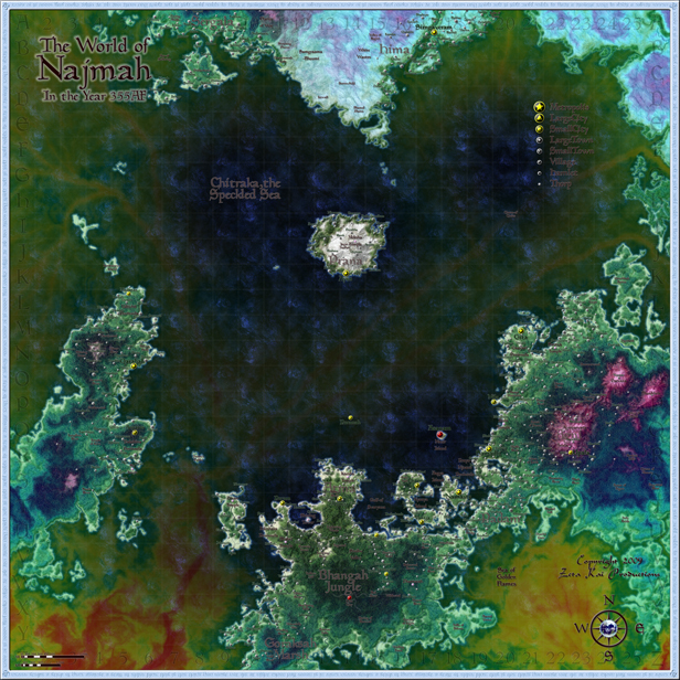
    Map The Hourglass of Zihaja: The World of Najmah

    This is a companion piece to my map of Siraaj. They are both of the same area, but on two separate planes, which are reflections of one another. It was made in Photoshop CS3 & Illustrator CS3 for a homebrew campaign setting called the Hourglass of Zihaja. It is an Arabian Nights based setting, made from the votes by the members of the Giant in the Playground homebrew forum.
    • Text in dark green is a settlement.
    • Text in dark brown is another location, such as an adventuring site, a geographical feature, or a region.
    • Every settlement larger than a thorp has a name.
    • Settlements in yellow are major cities.
    • Settlements in gray are lesser towns & villages.
    • Settlements in red are former towns that are uninhabited &/or in ruins.
    • Locations with a star on them are prominent locales (IE something that I have a lengthy description for).
    • The scale is in the lower-left corner, opposite the compass rose.
    • The blue lines in the oceans are major oceanic trade routes, which are mostly for the pahari & the marid genies.

    The world of Najmah is a mysterious place, full of bizarre happenings & magical events. Much of this is caused by the fact that the sun never rises here; the land is always dark, & the sky is full of stars. But another major factor contributing to the unknowable enigma of the Plane of Night is a strange multihued mist that pervades the air, land, & water in this dark & exotic land.

    Also known as kuuhaa, the mists of Najmah are everywhere. They widely vary in thickness from region to region, from mile to mile, & from day to day. On some days, the air is clear & virtually mist-free; at other times, the mist is as thick as the deepest fog.

    The names of various places are taken from actual Sanskrit, Hindu mythology, & authentic-sounding gibberish. The whole thing was made by painting it in Photoshop using my normal mapping techniques, tracing it in Illustrator to lay down the rivers, roads, & settlements, then porting it back to PS at a much high resolution & laying down more detailed textures on top of everything, & piling on filter after filter; I used some methods from Pasis, Ascension, RobA, & Tear. I hope you like this map in direct proportion to how much time that I spent working on it.

    For some reason, I've had trouble uploading images here in the past, & the big map is huge (4,925×4,925 pixels), so click on the thumbnail below to be linked directly to the big map hosted on DeviantArt.


  2. #2
    Guild Master Facebook Connected jtougas's Avatar
    Join Date
    Sep 2010
    Location
    Wales Massachusetts
    Posts
    2,813
    Blog Entries
    27

    Default

    This is beautiful
    I am the breath of Dragons...The Song of Mountains...The Stories of Rivers....The Heart of Cities.... I am A Cartographer....

    Finished Maps
    Kingdom Of Shendenflar Campaign Setting (WIP)

    Everything I post is free for use and redistribution under the Creative Commons Attribution-Noncommercial-Share Alike 3.0 licence, except where noted otherwise in the thread.

  3. #3

  4. #4
    Guild Member laevex_esre's Avatar
    Join Date
    Feb 2011
    Location
    Bracknell, Berkshire, UK
    Posts
    83

    Default

    Wow. I love the colours and textures of the sea and mountains. It looks really magical.
    The scale confuses me though. It's quite sparsely populated if you consider an area of several hundred miles only having a few towns in it. If you're going down to the thorp level at this scale then, in a normal world, you would have to put hundreds and thousands of settlements on this map. If you want it to be a sparsely populated world then that's fine though. Maybe not many people live there because it's constantly dark.

  5. #5
    Guild Apprentice Zeta Kai's Avatar
    Join Date
    Oct 2008
    Location
    Moving up north
    Posts
    35

    Default

    Yes laevex, this world is very sparsely populated. In centuries past, the world of Najmah was more densely inhabited, but the Great Calamity that took place 355 years ago emptied the southern & eastern continents, 7 the subsequent upheaval thinned the populations of the remaining lands. Since then, the world has recovered, but it is not yet back to the pre-Calamity numbers. Nowadays, the roads between the cities are long, dark, & lonely, filled with strange & dangerous creatures. The inhabitants keep mostly to the well-guarded routes, & people are willing to pay for armed escorts & pelt hunters. In a world of eternal night, everyone is looking for some small measure of light to guide their way.

    Here is an unlabeled version of the map, for those who would rather gawk at the geography & my passable texture work than look at all the roads & towns which are not relevant to you. For those who genuinely are interested in this world, its regions, its places, & its cities, you can check out the campaign setting (Hourglass of Zihaja) that this is based on here.

    For some reason, I've had trouble uploading images here in the past, & the big map is huge (4,925×4,925 pixels), so click on the thumbnail below to be linked directly to the big map hosted on DeviantArt.


  6. #6
    Community Leader mearrin69's Avatar
    Join Date
    Sep 2009
    Location
    Portland, OR
    Posts
    2,318

    Default

    Nice map. Yummy colors. Have some rep!
    M

Posting Permissions

  • You may not post new threads
  • You may not post replies
  • You may not post attachments
  • You may not edit your posts
  •