Page 1 of 4 1234 LastLast
Results 1 to 10 of 31

Thread: Commission at work

Hybrid View

Previous Post Previous Post   Next Post Next Post
  1. #1
    Professional Artist ThomasR's Avatar
    Join Date
    Nov 2015
    Location
    Angers, France
    Posts
    4,199

    Wip Commission at work

    Hi fellows,

    I've been commissioned by Rains, here in the forum, to draw a map for him.

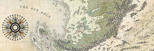
    Not much has been done for now and it'll stay that way for about ten days (deadline approaching on another map) but I figured a WIP thread would keep me motivated and some feedback wouldn't hurt either. Rains was kind enough to roll with it, so, here's the first WIP that's just a layout. The reference he pointed me to was my Towers map but, hopefully, at the size will be more modest here (17"x11"). You can spot a fancy but sturdy compass rose in the making in the top right corner that'll get a metal finish.

    You'll get updates as often as the commissionner and all input will be appreciated.

    Nuff said, here's the first one.

    1.jpg

    The base is pretty cool and my job will be to make it cooler

  2. #2

    Default

    Looks like a good starting point, I'm curious to see how it develops.

  3. #3

    Default

    Looks like you're off to a really solid start. I like the overall layout of the continent and it's shape. I do feel like the compass is just slightly too large for the space, and I personally would reduce it just a little. But other than that it looks really great.

    - Josh

  4. #4
    Professional Artist ThomasR's Avatar
    Join Date
    Nov 2015
    Location
    Angers, France
    Posts
    4,199

    Default

    Quote Originally Posted by Lyandra View Post
    Looks like a good starting point, I'm curious to see how it develops.
    Thanks Lyandra

    Quote Originally Posted by JoshStolarz View Post
    Looks like you're off to a really solid start. I like the overall layout of the continent and it's shape. I do feel like the compass is just slightly too large for the space, and I personally would reduce it just a little. But other than that it looks really great.

    - Josh
    Thanks Josh but the image is the prompt of the client. The landmass will most likely get some distortions and coastal islands to add some dynamism to the whole thing. I'll still respect the client's base, of course but he asked for me to add a personal touch and, as we'll make some more things up on the fly, it's bound to move a bit plus I feel the layout needs a little more balance. About the compass, you are perfectly right, he is oversized ATM and its final size will depend on the landmass layout.

  5. #5

    Default

    Ah okay I gotcha. Well, either way, I'm looking forward to seeing it progress. You always do awesome work.

    - Josh

  6. #6

    Default

    i'm digging it so far! the mountains and mountain ranges seemed well-placed

  7. #7

    Default

    Quote Originally Posted by DrWho42 View Post
    i'm digging it so far! the mountains and mountain ranges seemed well-placed
    Thank you! I found a browser based program that endeavors to create geographically coherent/realistic landmasses using a broad array of parameters, (how cold the poles are, how hot the equator is, etc). It will also allow you to change the height-map in specific areas and then recalculate the biomes, rivers, mountains, etc. For example, the mountains in the middle the program created on its own and then I put in some more on the west coast which it then adjusted for.

  8. #8
    Professional Artist ThomasR's Avatar
    Join Date
    Nov 2015
    Location
    Angers, France
    Posts
    4,199

    Wip

    Quote Originally Posted by Ilanthar View Post
    Nice ! That's a very complex coastline.
    It is complex, indeed but it's because I plan on adding lots of water ways

    Quote Originally Posted by Rains View Post
    Thank you! I found a browser based program that endeavors to create geographically coherent/realistic landmasses using a broad array of parameters, (how cold the poles are, how hot the equator is, etc). It will also allow you to change the height-map in specific areas and then recalculate the biomes, rivers, mountains, etc. For example, the mountains in the middle the program created on its own and then I put in some more on the west coast which it then adjusted for.
    Yup, the mountains were pretty rad. But you asked for a makeover so, here it comes .

    The mountains plus some propositions for more.
    3.jpg

  9. #9
    Professional Artist ThomasR's Avatar
    Join Date
    Nov 2015
    Location
    Angers, France
    Posts
    4,199

    Wip

    Thanks guys

    I'm finally done with my latest project and can really start on the map. The rose has been reduced and the coastlines are awaiting validation from the client.

    Here's the WIP.
    2.jpg

  10. #10

    Default

    Nice ! That's a very complex coastline.

Page 1 of 4 1234 LastLast

Posting Permissions

  • You may not post new threads
  • You may not post replies
  • You may not post attachments
  • You may not edit your posts
  •