Results 1 to 9 of 9

Thread: Worldmaps to view the planet in 3D?

Hybrid View

Previous Post Previous Post   Next Post Next Post
  1. #1

    Post Worldmaps to view the planet in 3D?

    Are the texture maps of the planet available in "simple cylindrical" projection? My searches of the forum and the wiki haven't found any, but maybe I'm searching for the wrong things.

    @Redrobes,

    In the thread World Pictures, ravells posted pictures of the planet which I understand were created by you using Fractal Terrain. Can that program be persuaded to export the corresponding surface textures?

    Free 3D viewers are available which can make it possible for anyone to view the world interactively. It would be quite easy to do with Celestia, for example, showing the planet orbiting an appropriate star.

    Celestia can display surface textures (ground coloration), bumpmaps or normalmaps (shading mountains, valleys and craters), specular maps (showing sunlight reflecting off the oceans and rivers) and emissive maps ("nightmaps", showing city lights, forest fires and volcano eruptions on the dark side), as well as clouds and their shadows. These are all drawn in real-time while the user is changing the viewpoint.

    Its AltSurface feature can be used to display a variety of surface texture images on the same planet, like climate or political maps. "Virtual Textures" make it possible to have very high resolution textures covering part or all of the planet's surface.

    One could, for example, zoom in and use AltSurface with VirtualTextures to display the regional maps which individuals have been creating.

    I would be glad to provide Celestia catalogs to implement some of these features, either here on the forum or on the Wiki.
    Selden

  2. #2

    Post

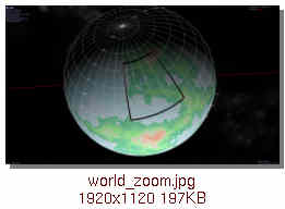
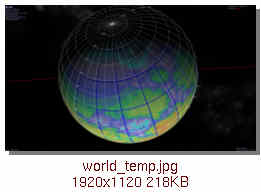
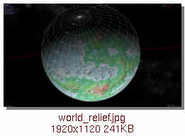
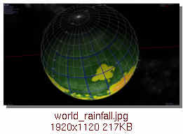
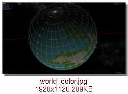
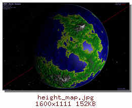
    Below are some Celestia screengrabs using the maps by NeonKnight and Redrobes which were posted by Airith in the World Pictures thread, with a long/lat grid overlay.

    I didn't edit the texture images, so they have different offsets in longitude because Celestia assumes that 0 degrees of longitude is in the center of a texture. I don't know if anyone has decided on a prime meridian for the world.

    A bumpmap would produce results similar to the relief map, but its shading would depend on the planet's rotation.

    @NeonKnight,

    Is it possible to persuade Fractal Terrain to produce images with darker water? That would look somewhat more realistic in Celestia, I think.

    In order: zoom, temperature, relief & rainfall by NeonKnight; world_color1 by Redrobes.
    Last edited by selden; 08-12-2009 at 07:57 PM. Reason: added remote images
    Selden

  3. #3
    Guild Apprentice WidowMakers's Avatar
    Join Date
    Sep 2007
    Location
    Michigan USA
    Posts
    36

    Post

    I have used this in the past to get me 3D earth shots and renders.

    WORLD WIND by NASA
    http://worldwind.arc.nasa.gov/manual.html

    Basically it can take many different images and map them to the earth (low and high rez stuff) I used it to help make the Canada map (see my albums)

    I am trying to figure out where and how to upload image tiles but I know you can.

    Here is a screen shot.

    EDIT: There are TONS of different tiles you can place over the earth. (weather, clouds, sea, elevation, climate, population. TONS of stuff). You can also (i think import NON earth images and they will respond the same. Might be a neat way to develop a very cool new planet.
    Attached Images Attached Images
    Last edited by WidowMakers; 08-12-2009 at 08:23 PM.

  4. #4
    Administrator Redrobes's Avatar
    Join Date
    Dec 2007
    Location
    England
    Posts
    7,288
    Blog Entries
    8

    Post

    Interesting thread and good to see Ansium getting some planetary treatment

    Quote Originally Posted by selden View Post
    One could, for example, zoom in and use AltSurface with VirtualTextures to display the regional maps which individuals have been creating.
    You might be interested in this movie then...
    http://www.viewing.ltd.uk/Temp/CG/VD_Demo2/Movie1.avi

    Quote Originally Posted by WidowMakers View Post
    WORLD WIND
    I have a project I am part of where we would like to export some high res (I mean really really high res) map in both ViewingDale format and in World Wind. In fact NASA have already agreed to host the map for us on their servers so WorldWind is a given really and in any case thats a good choice.

    I am presented with this 'dstile' ??? How big an image can it handle and can it do tiles of a bit map so that they all line up. Do you have some experience with this aspect of WW ? I suppose I should really say that the full size of the map is so big I would have no chance at all of holding it in one image. Its multi gig size. So I guess I really need a tiled solution.

  5. #5

    Post

    Here's Celestia's SSC catalog that i used.
    It'd be more appropriate for the world to be orbiting around some other star, of course, with its own orbit, year and day lengths.

    Code:
    "World" "Sun"
    { 
      Radius 6453.229 # km; circ = 40546.8 km
      Texture "world.*"
    
      EllipticalOrbit { SemiMajorAxis 1 Period 1}
    
      UniformRotation
    	 {
    	    Period         24
    	    Inclination    20
    	 }
    }
    
    AltSurface "Relief" "Sun/World" 
    {
    	   Texture "relief.*"
    }
    
    AltSurface "MeanTemp" "Sun/World" 
    {
    	   Texture "mean_temp.*"
    }
    
    AltSurface "AvgRainfall" "Sun/World" 
    {
    	   Texture "avg_rainfall.*"
    }
    
    AltSurface "Zoom" "Sun/World" 
    {
    	   Texture "zoom.*"
    }
    
    AltSurface "Color" "Sun/World" 
    {
    	   Texture "World_Color1.*"
    }
    Selden

  6. #6

    Post

    My own shading of the height map.

    I'll try modifying it by rainfall amounts next.

    Selden

  7. #7

    Post

    Redrobes,

    Celestia automatically subdivides single imagemaps. I don't know what its limit is for individual images, although it is a 32bit application, so it can't work for one as large as 2 GB. However, it essentially exposes that subdivision mechanism in its VirtualTextures. At the highest resolution level, it's limited to the size of texture that your graphics card can handle. Modern high-end cards can handle individual textures as large as 4K on a side, although older ones are limited to 1K on a side.

    Celestia VTs can handle as many as 13 levels of subdivision, for a maximum VirtualTexture size of 4Megapixels x 2Megapixels if 512x512 pixel tiles are used. The higher resolution VT levels don't have to be fully populated, so you only have to have high resolution images of the areas of interest. On a planet the size of the Earth, that yields a maximum resolution of about 10 meters/pixel for 512x512 tiles, and 1/8 of that or about 1 meter/pixel for 4Kx4K tiles.

    Smaller features can be provided by using individual 3D models placed wherever desired, separately from the use of VTs.

    The result looks much like what's in the video, except that it's drawn on a sphere. In addition to the surface texture, VT maps for specularity, bumps, nightlights and clouds are supported, too.

    Unfortunately, generating VTs isn't as easy as it could be, although some scripts have been written to help.

    Unlike WW, which uses DirectX and .NET and thus runs only under Windows, Celestia uses OpenGL and is available for Windows, MacOS and Linux.

    p.s. large VTs can be put on the CelestiaMotherLode, which is hosted by ibiblio.
    Last edited by selden; 08-21-2009 at 09:11 AM.
    Selden

  8. #8
    Administrator Redrobes's Avatar
    Join Date
    Dec 2007
    Location
    England
    Posts
    7,288
    Blog Entries
    8

    Post

    Thanks,

    I am an OpenGL man myself. I know that WW used to be OpenGL running under OpenSceneGraph but they have apparently changed to C# with directX. God knows why - some external pressure I presume or that the programmer was only familiar with that API. They give some real tenuous reasons for it in their FAQ. Still, its up to them.

    Interesting info on Celestia LODs. My ViewingDale is geared up for more arbitrary images instead of planets per se, so there are no fixed levels. It doesn't map onto a sphere like celestia and also its orthographic so no height field like WW or google earth.

    If we get this map on WW then maybe afterwards ill come back and see what we can do with Celestia too and maybe host on the mother lode too. Its a free map after all.

  9. #9

    Post

    Today I downloaded the Trial version of Fractal Terrains Pro to see if I could generate some grey-scale rainfall and temperature maps. The trial version only allows rather tiny images to be written to disk, but I managed to do some larger screengrabs at about 1Kx512.

    Unfortunately, after loading World4.ftw (available in World4.zip at http://www.cartographersguild.com/sh...&postcount=105 ) and saving the various maps that FTPro generated from it, I discovered that FTPro hadn't created exactly the same surface image as is being used for the CWBP. While the differences aren't major, the fact that there are any differences at all is distressing.


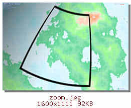
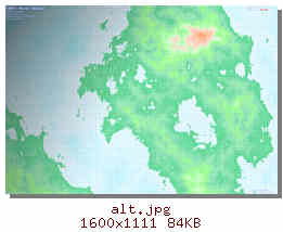
    zoom.jpg uses the map from the forum, alt uses the map generated by FTPro. It looks like it decided to use a slightly lower land height. There more small lakes and the mountains are lower, too.

    *sigh*
    Selden

Posting Permissions

  • You may not post new threads
  • You may not post replies
  • You may not post attachments
  • You may not edit your posts
  •