


Hi, nice to meet you all. First time poster, I hope we'll all get along.
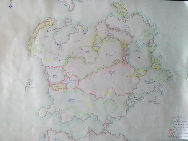
I'm currently making a fantasy world for a D&D-esk setting, and made a first world sketch. I like it thus far, at least as far as I can ever satisfy my own inner critic, but I do have some questions that I would like the imput of others of. I hope the details are clear enough to see. I know the writing isn't, unfortunately I don't have a way to scan the size of paper I used with a high enough resulotion for that. Perhaps the colour stuff is difficult too considering the quality of the image and me using markers that are literally over a decade old. But before I digitally trace the drawing and fix those issues, I would like to get some feedback on some things.
Legend:
-Pink are the alliance lands (with free humans.)
-Green stripes are magical/ancient/lushious wilds with the fey
-Green borders are the domains that the fey protect (when they don't own the land)
-Vague pink is Kil'Neah (fire giant) territory, a.k.a. the lands of the 99% certain antagonist of the campaign.
-Yellow are mountain ranges (Not every mountainous area is marked yellow, just the really mountainous ones.)
-Red stripes are polar/tundra lands.
-Blue is the border between the Earth and Sea realm.
Questions:
1) General opinion. I myself think the continent looks just a bit too ball-y despite my attempts to make it look good, but I'm wary of making multiple continents.
2) The land to sea borders. This is my main question for imput (and hopefully sparking a discussion). In my campaign in the early days before mortals, the earth and the sea gods were in a war to decide which phase should be the one to be the planet's surface. As such, I made the coasts a bit more jagged and with mountains as a literal wall against the sea here and there. So, my question is: How do I best shape a world where the coasts are shaped by an ancient war rather than natural events? How to portray conquest-defined borders similar to European ones after a few thousand years of peace?
3) Alternative city-shaping. The draconic lands (south-west and north-east) are devoid of big cities. I want to give them a different way to show the centre points of their infrastructure, but came up with zero good ideas to show it. Dragons would put more importance in their lairs than their kobolt-cities, and even their largest cities wouldn't actually be important ones. But I don't want to add a thousand little mountains or towns to the map, nor do I want to keep it entirely empty. Any ideas?
4) I have a few cities in the sea, but I don't want to make the map even more confusing by adding the borders of underwater kingdoms and their cities too. Should I just leave them out (and hope the party never develops a significant interest in the sea bottom other than a few important areas and sunken cities) or define these after all? Perhaps there's someone with a really smart idea?

 Reply With Quote