Page 1 of 2 12 LastLast
Results 1 to 10 of 12

Thread: [CC3] Arnhaal WIP, As well as Lore/Background Info

  1. #1

    Default [CC3] Arnhaal WIP, As well as Lore/Background Info

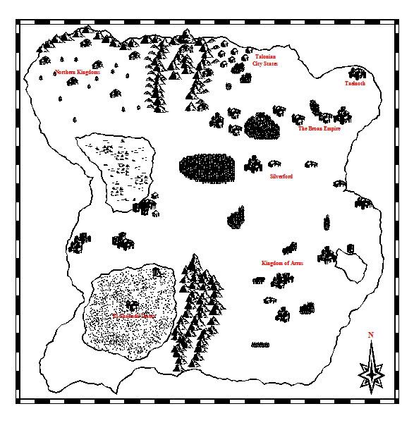
    Here's a very very very very bare bones basic black and white image of my world. It's horribly barren, because I am not ready for color yet I don't think. (seriously, I mess up the mountains big time)


    Anyway, here's some very basic info. The only label I have right now are the human kingdoms/nations. So I'll run down those first.

    Kingdom of Arrus - Probably the most "typical" feudal/medieval society. King, Barons, commoner-noble hierarchy. As of the story being written, slavery is outlawed, though the current King Thorgiin III is more or less breaking that rule by enslaving the Kashir race.

    Silverford - Feudal kingdom with a noble house hierarchy. Each of the major noble families has a specific "place" in line to hold the crown. Current King is Blair Callinwood II, next noble house is the Torland, then Nolus, followed by Demir, Stone, Greenfall, and Ashford. A few medieval Irish traits. They also have a "slave" system not like most countries. Slaves can easily work their way out of their servitude unless criminals.

    Broan Empire - The big powerful empire. Not as big as it used to be, the current Emperor is corrupt, and has a private mercenary army, the "Cambiare," who enforce the lawless city of Crestwind. The capitol is Goldenpoint, a spired city. Women are inferior in the empire, slaves are treated poorly.

    Talonian City States - Seven individual city states that form a loose alliance/union if one of the bigger countries threatens them. Otherwise, they act independently of each other, and have their own separate laws. The largest and oldest of these city states is Talonia, hence its namesake.

    Taelnoth - A mercenary and independent city state. They produce the strongest mercenary army in Arnhaal. Most countries court Taelnoth to get their hands on mercs.

    Northern Kingdoms - Think Norse barbarians. Still need fleshing out. There's three main kingdoms, each is slightly different.

    El-Shahadii - Desert dwelling people. Very decadent. Women are considered "things," and unmarried women are subject to any command a man gives her. Run by merchant kings, and ruled by powerful cultists.

    Those are the human kingdoms. here are some of the races BESIDES human.

    Guurhan - A tribal people. They are bound by the Grey Totem, and five tribal totems. These totems allow them to shapeshift into a creature that the totem is linked to. The five animals are the bear, the tiger, the wolf, the hawk, and the dolphin. There are variations of these animals based in clans. They are the elder race and the main "protagonist faction" in the novel in progress, "The Grey Totem." Outside of their "totem form" the Guurhan look like any human.

    Shiz'Roth - A tribal lizard people. They live in the Kogan Wastes, a namesake earned when they not only defeated, but they slaughtered a 10,000 man army that came to drive them from their swamps. Presently, they are not hostile, and merely wish to be left alone. The Shiz'Roth have a violent lifestyle, but if one befriends one of these scaled people, they have a friend for life.

    Kashir - A feline race. Rumored to be a splinter tribe of Guurhan, they have lost any sort of pure human form, instead permanently in a cross between their feline and human shape. Very tribal, very primitive. Currently being enslaved by Thorgiin III of Arrus. There are many tribes, each representing a different aspect of the great cats. The Lion tribes have been nearly hunted to extinction due to their aggressive nature. There are no tiger tribes, which is the reason for the rumor about them being a splinter tribe of Guurhan.

    Eluvarii - A mysterious people, they are humanoid, but slightly taller, much more lithe. They gravitate towards nature, and are said to wield the powers of the earth as a man might wield a blade. They are known as the "chosen few," as any member of this race wields considerable power. Once they held a great city known as Sanctum, but they were driven out by the Talonian City States over a bloody conflict. They became nearly hunted to extinction after a great Eluvarii war hero set the great city ablaze in a trap, with an entire army inside. The chosen few have been missing for many years.

    Shiz'Rokhan - A dragonbased race. They are dragonmen, and they live primarily on another continent, where they lord over many human kingdoms, as well as many other Shiz'Roth tribes. They are not seen in the 10th Prophecy (the general title for anything in my world) stories because of their primary location.

    The Narkul - Corrupt Guurhan. It is said that they were corrupted by an ancient relic containing the soul of a demon. The Narkul have no color, and are completely pitch black, thus blending in with shadow. Fire is the only thing that hurts them, and thus the only effective way to slay them is to light one's weapon ablaze. They were banished long ago.

    A minor note...

    The Guurhan are the only other race that really is due to get map notes because the Kashir are nomadic, the Shiz'Roth have no actual settlements, the dragon guys are on another land, and the Eluvarii are still technically hidden. Their primary settlements are on the eastern side of the mountain range, pretty much up against it as you might notice the small hut villages.

    Anyway, that's what I have so far to share!
    Last edited by torstan; 04-28-2011 at 09:24 AM.

  2. #2

    Default


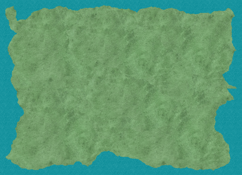
    Alright, so using four different files in CC3 and then combining them, this is the very basic of the continent. Before I even add details, I'd be curious in knowing what changes would be useful to make this more... interesting. Right now its basically a big blob, and I have no clue how to make it more realistic. This is where I need help big time with CC3.

  3. #3
    Administrator Facebook Connected Diamond's Avatar
    Join Date
    Jul 2009
    Location
    Boonsboro MD, USA
    Posts
    7,557

    Default

    I can't really give you any tips for CC3 since I don't use it, but I will say that I think the shape of your continent is far too square and regular. Nature abhors regular shapes, and this is about as regular a shape as you can get. You need some peninsulas, islands, fjords, something to make the whole thing a bit more irregular in shape.

  4. #4
    Guild Apprentice Hungry Donner's Avatar
    Join Date
    Apr 2011
    Location
    Dioscorida
    Posts
    49

    Default

    Quote Originally Posted by Diamond View Post
    I can't really give you any tips for CC3 since I don't use it, but I will say that I think the shape of your continent is far too square and regular. Nature abhors regular shapes, and this is about as regular a shape as you can get. You need some peninsulas, islands, fjords, something to make the whole thing a bit more irregular in shape.
    I agree. The shape in the first map is far better, and even it could probably use some tweaking so the northern and southern coasts aren't so parallel - I'd suggest having it bulge out around that southern mountain chain. It's rather odd having a mountain chain perpendicular to the coast like that, when it does happen (like with the Urals) the mountains usually hit the coast and then become a chain of islands.

    The El-Shahadii also quite the negative stereotype, it rather turns me off the whole thing. I do like your use of the rain shadow however to make the desert.

    The map is otherwise quite nice and I'd love to see how that large lake (small sea?) in the west impacts the various nations and peoples.
    Last edited by Hungry Donner; 05-01-2011 at 01:10 AM.

  5. #5

    Default

    Yeah, I am no good at landmasses. I've spent ALL weekend trying to come up with one thats convincing. I look at some of the maps on here and am just stunned... and it's not like I need a hugely professional map for my own personal reference, but I'm not sure how to make a map look so vast in size, even in just a sketch.

    And it's so -frustrating- because I feel like I NEED a map in order to have a reference sheet. And I can't get one made. I can't afford a cartographer, I suck at map making myself, etc. It's de-motivating me big time.
    Last edited by Bryden88; 05-01-2011 at 11:00 AM.

  6. #6
    Guild Apprentice Kaiser MacCleg's Avatar
    Join Date
    Mar 2010
    Location
    Wales
    Posts
    40

    Default

    I would suggest firing up Google Maps and finding some real world locations you like the look of. There's no need to copy what you see, only to use it as inspiration, and to get an idea for how landscape and topography affects the coastline.

    Some basic points: in most cases, an estuary will form where a river meets the sea. On a map, estuaries look something like this:


    Though of course you get all shapes and sizes. The Severn estuary, for instance, is hundreds of times larger than these examples.

    In certain circumstances, deltas can also form at the mouth of a river. Deltas form when the flow velocity of a river drops dramatically after reaching a body of standing water, causing sediment to drop out of the water column. Over time, this sedimentation can build up, and the delta "progrades" out into the sea/lake. The classic example is the Nile Delta, though you can get all sorts of shapes - have a look at the Mississippi's.


    Geology has a big part in defining the coast, so if you want, you can go into some detail thinking about that. The most basic rule of thumb is that softer rocks erode faster, so (in theory at least) if you have two rock types in an area - a soft rock bounded on both sides with a more resistant rock, a bay will be formed between two headlands. In practice it's much more complicated than that, but no need muddle things up further.

    You'll also find flooded river valleys all over the place - fjords and rias. The Norwegian coast is the prime example but you can find them all over the place. There are numerous good examples in the South-West of Britain, for instance.

    I think that's the sort of thing you need to think about. Try to come up with a more interesting shape for your continent, add in some estuaries, bays, headlands and islands, but don't crowd it out too much - have a look at some real world locations to get an idea of what's possible and what's not.
    Last edited by Kaiser MacCleg; 05-01-2011 at 01:55 PM.

  7. #7

    Default

    Well, after some thinking and digging around...

    I found a map of a previous world I tried to start up that I had commissioned a few years back, and after comparing lore notes with what I used to have, I think I'm sorta gonna start over. The problem with THAT world was that it wasn't developed enough, and the problem with my world now is that there's almost too much I want to do with it. Gonna find a happy medium - both with the maps I have, and with the lore I have from both.

  8. #8
    Community Leader Facebook Connected Ascension's Avatar
    Join Date
    Jun 2008
    Location
    St. Charles, Missouri, United States
    Posts
    8,392

    Default

    You only need something sketchy in order to have reference notes. Draw a doodle on a napkin and write stuff like "500 miles from A to B but the hilly terrain takes a month on horse" and "600 miles from B to C but it's mostly flat so it takes 2 weeks". For that sort of stuff you need to have your story already written, though, and you need to remember the journey. Otherwise just put dots for your towns, roads where there are roads to speed travel, mountains, hills, lakes, rivers, forests, and swamps. That's all you need really, the rest is just making it look pretty. Here's a 10 minute doodle.
    Attached Images Attached Images
    If the radiance of a thousand suns was to burst at once into the sky, that would be like the splendor of the Mighty One...I am become Death, the Shatterer of worlds.
    -J. Robert Oppenheimer (father of the atom bomb) alluding to The Bhagavad Gita (Chapter 11, Verse 32)


    My Maps ~ My Brushes ~ My Tutorials ~ My Challenge Maps

  9. #9

    Default

    Yeah... I am possibly too ambitious to just sit with a doodle. That said, I do have a rough sketch with some base locations marked. But I am interested in the cartography aspect of it. Just gotta learn.

  10. #10

    Default

    I think there are a couple of things you can try to make your world a bit more interesting. I have the same problem you do, and It takes me forever to get it right. I also use CC3, and am familiar with its capabilities (as a pure amateur anyway), although there are most people on here are much better at it than I am.

    - I would change your fractal lines to have more bends in it. (I forget what the key is, but you can adjust them with a key as your are drawing. This is the time where a more experienced CC3 user would help.

    - Sometimes when my map seems to angular or regular, I start doing just random movements with my mouse, and moving it around the map and seeing what comes out. delete, and redo. After a shape seems like it is close to what I want, I delete, and follow along the outline of the old map, but begin making some specific adjustments to get it to where I want.

    - definitely add some places where there are peninsulas, islands, and the like

    Sorry if my advice is a bit off center, I'm new to the forum and am not used to relating my experiences with maps. I'll go back to CC3 and see if I can't figure out that key.


    ----- Edit- U use the up and down arrow to control the fractal path. ------
    Last edited by davros; 05-01-2011 at 03:03 PM.

Page 1 of 2 12 LastLast

Posting Permissions

  • You may not post new threads
  • You may not post replies
  • You may not post attachments
  • You may not edit your posts
  •