Results 1 to 5 of 5

Thread: First map Attempt

  1. #1

    Default First map Attempt

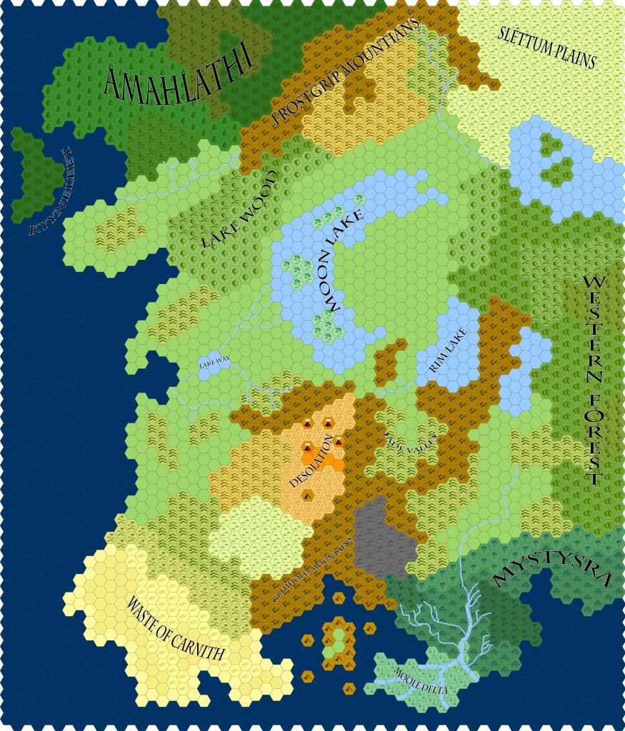
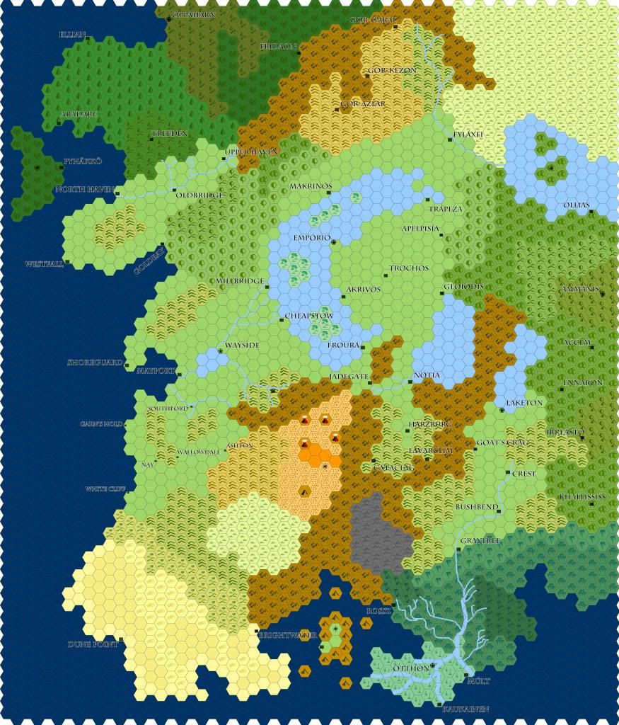
    This is my first map attempt at something that looks semi-good. It is a combonation of Hexographer and Photoshop. A few things become clear at looking at it. It is still a draft and needs alot of work.

    Any feedback would be nice.


  2. #2

    Default

    I like the style of your map. The first thing that came to mind when I saw it was Dwarf Fortress Catan. It's different from almost all the maps I've seen around here. A good start.

    Some things I would change, however, are the text font, which is unreadable on both maps, especially when the text is over the water. The larger fonts on the first map are good but the rest you should have a look at, possibly change the color or the size or the placing.
    As for the edge of your map, with the white hexes lining it, I would look into a border of some kind or filling up the white spaces with the same ocean blue you have for the rest of the map.
    A legend of some kind would also be interesting. While I can guess the purpose of most of the hexes some of them are too similar. On the edge of "The waste of carnith" you have mountains and hills and behind those hills you have other hills and connecting to those hills you have other other hills.

    Do you have some setting/story in mind for this map or is it only for practice?
    Last edited by holyhalo; 01-24-2014 at 09:31 PM.

  3. #3
    Guild Member Zach's Avatar
    Join Date
    Jan 2014
    Location
    New England
    Posts
    61

    Default

    Hex maps! I like hex maps, especially ones larger than regular Catan size. It makes me imagine massive games of Catan played by a giant group of people.

    I second a lot of the things holyhalo said. I recommend a solid black font rather than the black with white outlines you have, at least for the towns. It would dramatically increase the readability. Also, it's weird how "Western Forest" is vertical text (letters on top of each other) while all the other labels have horizontal text.
    That being said, a couple other map labels are visually distracting. Desolation and especially Moon Lake are at too vertical of an angle. You don't want map readers to have to turn their heads sideways to read it. I think if you just labeled the top half of Moon Lake it would still work.
    A couple pieces of text - Mystysra and Fade Valley - are too sharply curved for their size.
    Rather than filling the edge with ocean tiles, what if you just cropped all the white out of the image?

    I hate to be a junior river policeman, but there are some issues with the waterways in this map. There are two separate bodies of water, Rim Lake and the unnamed lake next to it, which have no visible outlets (this implies the water either evaporates or sinks back into the ground as fast as new water is added, both of which are rare for lakes). If showing where the water flows out is not the point of this hex map, that's okay.
    But the rivers in the Mystysra/Moole Delta region don't really work. The river sources on the northeastern shore of the bay follow along the coast for a while, which must mean that the land between it and the bay is pretty high, and I dunno whether that works here. Then when all the rivers come together, it splits into five different rivers that drain into the bay. Rivers simply don't do that. If the river does have a delta, it will form in the classic triangular shape, not a peninsula.

    Anyway, I think this is off to a great start. Keep at it. Like holyhalo, I also am interested in the purpose you have in mind for this map.

  4. #4
    Guild Journeyer
    Join Date
    Dec 2013
    Location
    Maryland, USA
    Posts
    123

    Default

    Hello:
    I am a huge fan of Hexographer. I am currently using it to map our world for the Living World of Alquennas. The map looks good. Have you thought about the water depths off of the coast lines? Creating the difference between shallow water and deep water?

    Tracker

  5. #5

    Default

    Quote Originally Posted by holyhalo View Post
    I like the style of your map. The first thing that came to mind when I saw it was Dwarf Fortress Catan. It's different from almost all the maps I've seen around here. A good start.
    Thanks!

    Some things I would change, however, are the text font, which is unreadable on both maps, especially when the text is over the water. The larger fonts on the first map are good but the rest you should have a look at, possibly change the color or the size or the placing.
    As for the edge of your map, with the white hexes lining it, I would look into a border of some kind or filling up the white spaces with the same ocean blue you have for the rest of the map.
    It is interesting that you mention font. I used straight black at first, but my gaming group said it was hard to read. Perhaps it is the photobucket size? On my high res desktop version the text looks fine?

    A legend of some kind would also be interesting. While I can guess the purpose of most of the hexes some of them are too similar. On the edge of "The waste of carnith" you have mountains and hills and behind those hills you have other hills and connecting to those hills you have other other hills.
    Yes, the legend. As a big map person, I feel the lack. I wasn't sure where or how to do it though. I am pondering it though.

    Do you have some setting/story in mind for this map or is it only for practice?
    I was going to make a world but I think it'll just be practice. It does have history though.

    Quote Originally Posted by Zach View Post
    Hex maps! I like hex maps, especially ones larger than regular Catan size. It makes me imagine massive games of Catan played by a giant group of people.
    Thanks!

    I second a lot of the things holyhalo said. I recommend a solid black font rather than the black with white outlines you have, at least for the towns. It would dramatically increase the readability. Also, it's weird how "Western Forest" is vertical text (letters on top of each other) while all the other labels have horizontal text.
    See above for text.

    I didn't think of the Western Forst thing. Good point!

    That being said, a couple other map labels are visually distracting. Desolation and especially Moon Lake are at too vertical of an angle. You don't want map readers to have to turn their heads sideways to read it. I think if you just labeled the top half of Moon Lake it would still work.
    A couple pieces of text - Mystysra and Fade Valley - are too sharply curved for their size.
    Too sharp? That is hard to tell on your own. Exactly the feedback I need. Thanks.

    Rather than filling the edge with ocean tiles, what if you just cropped all the white out of the image?
    This might work, yes. Good idea.
    I hate to be a junior river policeman, but there are some issues with the waterways in this map. There are two separate bodies of water, Rim Lake and the unnamed lake next to it, which have no visible outlets (this implies the water either evaporates or sinks back into the ground as fast as new water is added, both of which are rare for lakes). If showing where the water flows out is not the point of this hex map, that's okay.
    But the rivers in the Mystysra/Moole Delta region don't really work. The river sources on the northeastern shore of the bay follow along the coast for a while, which must mean that the land between it and the bay is pretty high, and I dunno whether that works here. Then when all the rivers come together, it splits into five different rivers that drain into the bay. Rivers simply don't do that. If the river does have a delta, it will form in the classic triangular shape, not a peninsula
    .

    Part of the issue is rivers are very clumsy and ugly in Hexographer. Your points on geography is well-noted. Perhaps I'll make the rivers in Photoshop next time?

    Anyway, I think this is off to a great start. Keep at it. Like holyhalo, I also am interested in the purpose you have in mind for this map.
    Thanks!

    Quote Originally Posted by Tracker View Post
    Hello:
    I am a huge fan of Hexographer. I am currently using it to map our world for the Living World of Alquennas. The map looks good. Have you thought about the water depths off of the coast lines? Creating the difference between shallow water and deep water?
    Tracker
    I personally thought using various shades of water was distracting. Maybe I shall experiment with it.

Posting Permissions

  • You may not post new threads
  • You may not post replies
  • You may not post attachments
  • You may not edit your posts
  •