Reply With Quote


The one that springs to my mind are these:
https://en.wikipedia.org/wiki/Panorama_Tools
Panorama Tools
Not sure whether it can do what you need tho.


Hi All,
I never thought I'd be speaking to Cartographers about film-making, but I suspect this forum is going to get flooded in the next few months, and Cartographers are going to be in vogue once the VR filmmaking community discover you.
My search for "compositing" regular elements over an equirectangular image with the correct remap/distortion is what brings me here.
What I would like to do is;
- I have a full "dome" image from a 360 lens camera (ricoh) The camera stitches the image internally into an equirectangular image for panoramic viewing
- I'd like to straighten out this equirectangular image into a normal projection (Gnomonic?) in software such as Photoshop or aftereffects
- Once straightened out, I'd like to add regular elements such as Text, signs, people etc..
- Finally, re-warp the image back to it's original equirectangular projection.
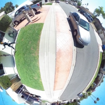
I've attached an image example.
I've downloaded G-projection, but when I choose gnomonic mapping It doesn't show the "whole" image, just a section of it. Could it be because the image is 3584 pixels wide?
Secondly, would G-projection then be able to wrap such a gnomonic projection image back to equirectangular?
Any help much appreciated.
Kind Regards.
Comp 1_S3D_LF (00000).jpg
The one that springs to my mind are these:
https://en.wikipedia.org/wiki/Panorama_Tools
Panorama Tools
Not sure whether it can do what you need tho.
Azimuthal Equidistant, instead of Gnomonic, might work better (though not perfectly) in that you can set the radius up to 180 or whatever you need.Originally Posted by cly3d

As to the second question, G.Projector can only change stuff from equirectangular, but there are one or two programs that can do otherwise. I use a little one on occasion, called Reproject Image (I think you can still download a zip file from this thread: http://www.cartographersguild.com/tu...tml#post247290 ) but the export quality may not be what you need it to be.
--- EDITED to remove g.project -----
you will likely find that using a cube environmental map will work a bit better than one in SimpleCylindrical
unless some EXTREME care is taken , there will be noticeable image errors at the top/bottom ( north/south poles)
seeing as this is for a VR set up
i am betting you already are using Blender or 3dStudio
Hugin should be able to stitch together individual images and remap that to a SimpleCylindrical environmental map
as to undoing the image in the top post
converting it into 3 images
--
top
middle ( many images centered on the area you are working on )
bottom
--
and then remapping it back
i use gis software normally and that can be a bit COMPLEX to use
that is why i have not been using itG.Projector can only change stuff from equirectangular,
However
for simple editing "The Gimp" has a nice tool "polar projection "
this is VERY handy for the top and bottom of that image
You can remove the tripod from the image
the filter
filters / distorts / polar coordinates
now there is a old'ish bit of software called
"Matthew's Map Projection Software"
http://www.users.globalnet.co.uk/~arcus/mmps/
for somethings it works great , others???? not so much
your image in the first post can be remapped in the terminal
the input HAS to be in PPM format , i renamed it for ease of use
-- the Southpole
Code:project stereographic -w 500 -h 500 -long 0 -lat -90 -f 1.ppm > 2.ppm
or the added animation of the girl
Code:project stereographic -w 500 -h 500 -long -72 -lat -2 -f 1.ppm > 3.ppm
Last edited by johnvanvliet; 11-02-2014 at 12:07 AM.
Thank you everyone for the many ideas and suggestions. I'm trying to wrap my head around some of the software and methods mentioned.
I'm not adept at 3Dmax or blender, and will be using a lot of photoshop and aftereffects.
I'll download Gimp (haven't used it before), and what I'd really like to know is how the Distort Polar filter is used to clean up the tripod, Johnvanvliet.
Was there also a cut and paste/cleanup involved as well?
I guess I still have to find a simple way to warp regular elements such as signposts, logos etc (I assume you'd call them gnomonic projected?) into the equirectangular space that the background picture is.
Will try out Mathew's Map Projection software and report back.
Kind Regards.
All i did on the remapped image of the ground was a simple "clone" and "heal"
and a quick job at that , you can see the errors i left in the lighting
do to how a distort works ( this is the same in photoshop)
you paste back into the original the the fixed area
Visual effects in a spherical pano is one of the major hurdles we're looking at right now for VR work. The plan right now at the company I work for is to find a way to get the raw individual camera views from a Bubl ( bubl ? 360º camera technology for everyone ) and work out an undistortion workflow on those. Then the vfx can be redistorted, composited with the raw plate, and handed to the stitching algorithm.
To be honest, I'm a little hesitant to dive right in with the Bubl because it doesn't shoot in stereo, and I think that's going to be a big prerequisite for a satisfying VR experience. On the other hand, I have a hard time wrapping my brain around a camera geometry that would allow a 360-degree stereo image. I'll admit that I haven't tried to draw it yet, either, so maybe it's easier than I think it is.
All of that to say that I haven't worked out an approach yet, but when we get our camera and get to start experimenting I'll report back.
Bryan Ray, visual effects artist
http://www.bryanray.name
Midgardsormr you are describing what i do with ISIS3
i work on the outside of a sphere and you on the inside of a sphere ( a world environment map )
it is rather easy to take a image say of the moon "Mimas" ( AKA "the Death Star moon" of Saturn ) and convert it to a mapped image
i work on camera images then remap them to simplecylindrical and polarstereographic
hugin can even do some of that if you KNOW the views coming from the camera and they never change
For me .I assign a lat/long to every pixel then mapping is easy
( well easy if a control network is also made for the measurement errors )
4 wide-angle cameras in a tetrahedral configuration looks to make for an interesting device. You should actually be able to get some stereo effects in most directions due to overlap in the raw fields of view (as long as it's not too close to the cameras, of course).
 Posting Permissions