Page 1 of 2 12 LastLast
Results 1 to 10 of 14

Thread: My first map

  1. #1

    Default My first map

    Hello all,

    Not sure if this is the correct place, but here goes.
    Having started making my own map I have immediately run into some problems, mostly, where to place mountains and how to make climates have sense.

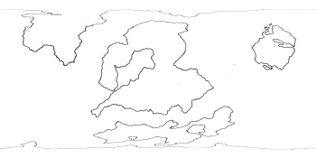
    Below is my first sketch of the world`s continent and nothing more than that. it has the coastlines and I`m stuck.
    I have a general idea on where I want mountains and jungle and desert and such ( see the 2nd picture ) but I have no idea if it makes any sense to place them where I want.

    worldmap_blank.jpg

    worldmap_color_sketch.jpg

    Since this is a top down map of the entire world I struggle with scale as well, is such a massive mountain range even logical/possible??

    I have looked for tutorials or guides or any other form of help regarding maps on this scale but still struggle with it

    I also want to have some form of barrier separating the island to the right with the continents in the middle (placed along the black line)

    worldmap_color_sketch_barrier.jpg

    I was thinking of making this in the form of Mountains or simply permanent stormy weather/whirlpools etc but I was wondering if and how this would affect the climates around the world.

    I hope someone here can help me with my many questions

    Just me Out.

  2. #2
    Guild Artisan
    Join Date
    Sep 2014
    Location
    Paris & Berlin
    Posts
    610

    Default

    So apparently you are out for a world scale realistic map.
    Then the first advice I'd have is to take an equirectangular projection : 2 wide and 1 high. This gives natural coordinates because you go between - 90 and + 90° vertical and - 180 to + 180° horizontal. Equator is right in the middle.
    From there scales follow. F.ex for a Mars size planet (rather small) you have 11 000 km from top to bottom.
    For an earth sized planet it would be about double.

    And no, the mountains ranges would not be so big.
    As to where to put them there is a whole story of plate tectonics that I won't go into. But you'd find them generally on the edge of continents following the coast (e.g Rockies) or on places where a peninsula is colliding with a continent (e.g Alpes, Himalayas)
    Also how do you intend to do that ? By hand ? With a software ?

    For your barrier you could have a line of several volcanic islands.

  3. #3
    Community Leader Facebook Connected Ascension's Avatar
    Join Date
    Jun 2008
    Location
    St. Charles, Missouri, United States
    Posts
    8,392

    Default

    Sea monsters work well to stop people from snooping too close to that island. Or if the inhabitants are cannibals or really really nasty mean pirate-types. If you want something more natural then the fog is a start, you could put in a long reef, a very active Mid-Atlantic trench, or a geologic hot-spot like the Hawaiian islands, or a methane vent sorta like in the Bermuda Triangle that sinks ships, or some sort of magnetic anomaly that messes up a compass, or (what makes most sense to me since it explains the fog idea) an underwater super-volcano like Yellowstone.
    If the radiance of a thousand suns was to burst at once into the sky, that would be like the splendor of the Mighty One...I am become Death, the Shatterer of worlds.
    -J. Robert Oppenheimer (father of the atom bomb) alluding to The Bhagavad Gita (Chapter 11, Verse 32)


    My Maps ~ My Brushes ~ My Tutorials ~ My Challenge Maps

  4. #4
    Guild Expert johnvanvliet's Avatar
    Join Date
    Jul 2012
    Location
    N 42.39 W 83.44
    Posts
    1,091
    Blog Entries
    4

    Default

    a few things

    --- just an opinion
    - take it or leave it

    one
    Are you using " MS paint "
    yes with time a Rembrandt / Van Gogh / Picasso type person can create a masterpiece
    But there are better photo / drawing programs out there and they are FREE


    two
    map projection

    http://en.wikipedia.org/wiki/List_of_map_projections

    for a full planet "equidistant cylindrical " also known as "Simple Cylindrical" works well with software
    viewing the poles ??? there is a lot of projection distort

    Mercator
    ???? poles are missing

    for drawing "Miller" works
    and it works if you are NOT going to use software to render it


    have looked for tutorials or guides or any other form of help regarding maps on this scale but still struggle with it
    look at real maps

    The USGS has a nice collection
    http://astrogeology.usgs.gov/maps
    (i do too , but they are not in a format for easy viewing )

    from looking at the first two images it looks as if you are using a "Mercator" projection
    http://en.wikipedia.org/wiki/Mercator_projection

    MOST maps of REAL planets tend to use "Simple Cylindrical" in what is called a "Planetocentric" mapping
    ( if it is the WHOLE PLANET )

    180 degrees top to bottom and 360 degrees side to side
    so a map with the width of 3600 pixels and a height of 1800 pixels has a resolution of ( 10 pixels per degree)
    -- very easy to calculate the lat / long of an area


    or a mix of two
    like this one from the usgs's pigwad
    http://astropedia.astrogeology.usgs....ation_full.jpg


    I was thinking of making this in the form of Mountains or simply permanent stormy weather/whirlpools etc but I was wondering if and how this would affect the climates around the world.
    as to climate

    most planets and moons tend to rotate the same way
    counterclockwise looking down on the North pole
    -- the laws of physics and thermodynamics are to blame for this

    this is why there are hurricanes and typhoons , counterclockwise and clockwise respectively

    this also causes Prevailing winds
    http://en.wikipedia.org/wiki/File:Ea...ation_-_en.svg
    this will have an impact on "rain shadow" deserts
    Last edited by johnvanvliet; 12-12-2014 at 11:13 PM. Reason: added to
    --- 90 seconds to Midnight ---
    --------

    --- Penguin power!!! ---


  5. #5

    Default

    Thanks for the answers,

    Regarding the scale of the map, does this make more sense ( this is the equidistant cylindrical projection right? )
    worldmap_blank_7200x3600.jpg

    I`ll have a look at the plate tectonics and how they work.

    @Ascension, I`ll probably combine some of those ideas. Maybe something like a "monster" infested area surrounding a massive (partially underwater) volcano range. will have to work on that

    @johnvanvliet, at the moment I am indeed using MS paint since I`m still learning how to work with Photoshop.

    Also, what did you mean with the poles are missing?

    Thanks for the tips

  6. #6
    Guild Artisan
    Join Date
    Sep 2014
    Location
    Paris & Berlin
    Posts
    610

    Default

    Quote Originally Posted by Justme View Post
    Thanks for the answers,

    Regarding the scale of the map, does this make more sense ( this is the equidistant cylindrical projection right? )
    Yes it does. It is not equidistant because distances are not conserved but equirectangular - the rectangles Lat x Long have all the same size. And yes it is a cylindrical projection.
    Your map looks now like that in equirectangular :
    Worldequi.jpg

    When ported on a sphere it does that :
    World.jpg

    And you notice that your central continent is (too ?) huge. It occupies almost a whole half planet. Perhaps that's what you want but I find it a bit too dominating and would break it up in smaller parts.
    Also your planet has big Antarcticas on both poles so that it will be rather cold.

    Last is that if you contemplate spending more than a few days with maps, you should go for GIMP (it's free).
    That way you won't waste your time with a software you won't use anyway and your time spent on working with your map will also serve to climb the steep Learning curve.
    2 flies with 1 stroke - It just saves time.
    Last edited by Deadshade; 12-15-2014 at 01:41 PM.

  7. #7
    Guild Expert johnvanvliet's Avatar
    Join Date
    Jul 2012
    Location
    N 42.39 W 83.44
    Posts
    1,091
    Blog Entries
    4

    Default

    Also, what did you mean with the poles are missing?
    in Mercator projection there is a nasty error built into it ( one normally ignored ) an INFINITY at the poles
    I have been relooking at a map of venus i did a while ago so this data is fresh with me and a good example

    so a real world example
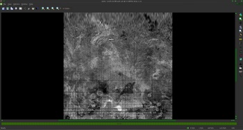
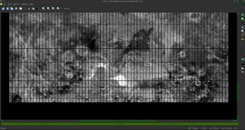
    a screenshot of my 64ppd merged reflectance radar map of venus
    ( simple cylindrical with the prim meridian in the center )
    90 north to 90 south


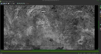
    mercator 45 north to 89.9 north


    close up - the grid is at 5 degrees
    45 to 85 north- the top gridline is 85 north


    the bottom gridline is 85 north and the top if the image is 89.6 deg


    as you approach the pole the height of the image starts to approach infinity ( ∞ )


    so a lot of the time the area 80 to 90 north/ south are ignored and just called 90 n/s
    or
    not even mapped

    a lot of the time 60 north to 60 south are used for a map in Mercator projection
    with the two poles then shown in polarstereographic for 60 to 90
    --- 90 seconds to Midnight ---
    --------

    --- Penguin power!!! ---


  8. #8
    Guild Expert johnvanvliet's Avatar
    Join Date
    Jul 2012
    Location
    N 42.39 W 83.44
    Posts
    1,091
    Blog Entries
    4

    Default

    slightly different note
    the scale mentioned above ( or what i would call proportions )
    --- "scale" would be the pixels per degree --

    from the proportions in the first map

    assuming Mercator

    it is about 81 north to 81 south for that width and height of the image
    so using my mapping software this is what is will look like as a Simple Cylindrical map
    90 north to 90 south


    while a planet could be like that ( there is no reason it could not)
    from a "artistic " point it is not fallowing the "rule of thirds "

    so if it was something i was making
    then
    shrink the center continents and enlarge the pole area a bit


    but

    it is your map
    --- 90 seconds to Midnight ---
    --------

    --- Penguin power!!! ---


  9. #9

    Default

    @ Johnvanvliet
    Looking at the images with new knowledge the center continents do indeed look to big, I`m going to change those a bit. and regarding the pole areas, do you mean expanding them in height a bit?

    @ Deadshade, I`ll give Gimp a go as soon as I get home (is that also the program you used to give the map color? )

  10. #10
    Guild Artisan
    Join Date
    Sep 2014
    Location
    Paris & Berlin
    Posts
    610

    Default

    Quote Originally Posted by Justme View Post

    @ Deadshade, I`ll give Gimp a go as soon as I get home (is that also the program you used to give the map color? )
    No I did that map with a very fast job in Wilbur (3D, fractal, realistic software) because I just wanted to demonstrate the scales and projections. I wouldn't recommend trying Wilbur right now unless you have steel nerves and plenty of time.
    I think GIMP will be already enough (but GIMP like PS is not a 3D software).

Page 1 of 2 12 LastLast

Posting Permissions

  • You may not post new threads
  • You may not post replies
  • You may not post attachments
  • You may not edit your posts
  •