Step 4, winds:
Use the pictures to figure out how the winds are blowing. Figure A
Or use the main map at the bottom at the page.
All the figures are from the North Hemisphere except E.
climate-graphics.jpg
Dominant winds
Near the equator, the dominant winds are usually blowing to the west (Trade Winds)
In mid latitudes, its blowing to the east (Westerlies)
And close to the poles they are blowing to the west again (Polar Easterlies)
Wind usually flow from the highest pressure to the lowest. The larger the difference in pressure between two areas, the stronger the winds will be.
Inside a large high or low pressure zone, the winds can be very weak. Figure B
Mid latitudes winds: Starting with your low pressure bands at high latitudes, the Westerlies should blow from west to east where its blue, and where there are no colors. Avoid the red.
Low pressure have 2 types: Hot season: converge like the ITCZ in Asia, see figure F
And those of the mid and high latitudes, the North Pacific (round , isolated) and the North Atlantic (continuous band of low pressure) Figure G
The high pressure systems at mid latitudes (also called subtropical highs): Draw the poleward winds first. They have a curved shaped because they quickly change direction when encountering the Westerlies. Figure C
Winds blowing from the equatorward side of the system tend to blow toward the equator, or if any, toward the closest low pressure center.
Winds are converging near the equator; they tend to blow to the west. Figure D
Polar highs: The high pressure systems on the poles brings dry and extremely cold temperatures. Figure E (South Pole)
Overland highs are spinning according to the schema. See Figure A, or look at Eastern Asia in winter.
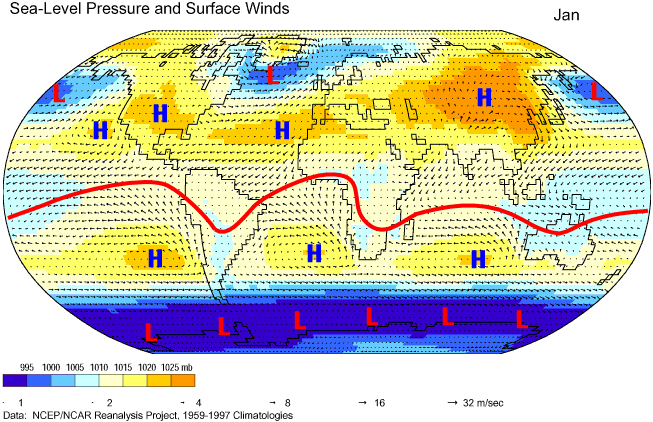
January winds
jan winds.jpg
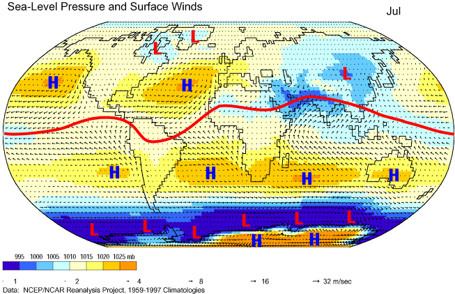
July winds
jul winds.jpg


 Reply With Quote