Page 2 of 3 FirstFirst 123 LastLast
Results 11 to 20 of 24

Thread: New to map making, photoshop and basically everything - my first map attempt

Hybrid View

Previous Post Previous Post   Next Post Next Post
  1. #1

    Default

    Quote Originally Posted by Tiluchi View Post
    Hi Mats,

    First of all, this is a great start, especially for someone new to Photoshop! I'm impressed. Not sure if I'm nearly expert enough to answer your questions, but I'll give a stab at some of them.

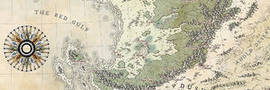
    Those circles are awfully close together! I'm guessing your planet it somewhat colder than Earth. It's a little hard to get a good sense of scale here, as I'm used to seeing equators as straight lines in most map projections. As Hai-Etlik said, it looks like you're using some sort of equidistant conic projection, such as what we use for the US. It may be helpful for you to try sketching some sort of version of your world map (even if it's just this continent for now!) and putting it in an app like GProjector to see how this would compare to the US in size. Anyway, if that upper semicircle really is the Arctic Circle, then is it realistic to have forested areas above it? On Earth, the treeline ends well south of the Arctic Circle.

    If this really is a US-size continent, then I'd recommend making your mountains somewhat more complex- if you look at a map of the US, you'll see that big mountainous areas like the Rocky Mountains are actually broken up into dozens of smaller mountain ranges rather than a single cordillera like you have here. So in an area this big, you'd almost certainly have valleys and even plains in between mountain ranges. That said, I rather like the style of mountains you have so far, though I'd recommend making them smaller and more frequent.

    As for style, I like the pine trees you have (though some of them are a little fat and/or irregular), but I'd recommend drawing them smaller and having more of them (I guess that's a trend here!). It's a little more time consuming, but when they're this size they look a little awkward when I view the map at full size. I'm not really convinced by your style for deciduous forests- but that's also one of the hardest landforms to get right (in my opinion), so I don't know if I have any tips for how to improve them.
    Thanks for kind words I've posted a full map in the reply above to give a better perspective. You're right that it's supposed to be colder than earth. I missed the scale with mountains and forests, I see that clearly now Are there any good examples for this style maps representing real world features - that would really help me with the perspective... I know it's a basic question and I tried googling it but I don't know what are maps with this style called so I didn't have much success...

    As for style - my hand really needs to get used to tablet and photoshop. The first tries were terrible and these are just barely acceptable for me. I think I'll try to make forests more circular, to give the map a more geometric feel but who knows how it'll turn out. I'm researching maps here on the forum and still searching for a good mix of what I like and what I can reproduce

    Thanks for really insightful feedback!

    Quote Originally Posted by kacey View Post
    Great start! I really like the coastline. Keep up the good work.
    Thanks!

  2. #2

    Default

    Quote Originally Posted by mats View Post
    How would land transform from pastures/mountains/forests into desert?
    Hi Mats

    That's a very nice map for a first attempt.

    And its also a lot of questions, so I've trimmed the quote down to the only one I think I might be able to help with.

    I have no formal qualification to back up my understanding, but it would seem natural that woodland would thin out to small patches and then single isolated and rather stunted trees with increasing altitude, or as it becomes pasture or scrubland. The same I would imagine would apply to pasture becoming less healthy and more patchy as it turns into scrubland/desert. To go from forest to desert you would have to transform the forest to patchy trees on pasture, then pasture thinning out to scrub, then scrubland to desert. The distance involved would depend on the scale of the map.

    A map can start to look a bit scruffy if everything is so vague, however, so a happy medium may be required?

    Like I said, I have no formal qualification in climatology or ecology or anything. It just seems more natural than having a sharp line along the edge of natural growth. The only hard lines I've ever seen are where there's a dirty great big mountain range and different climates on either side of it, or made by man - particularly where forestry and farming are concerned. If your land is inhabited, it may have a few of those sharp lines, even if the mountain ranges don't affect the gradation of one ecology to the next.

    Man made sharp lines tend to show more clearly with altitude, than they do with region (unless you have half an untouched desert, while the other half has been irrigated for arable farming)

    Hope that helps a bit

  3. #3

    Default

    Quote Originally Posted by Mouse View Post
    Hi Mats

    That's a very nice map for a first attempt.

    And its also a lot of questions, so I've trimmed the quote down to the only one I think I might be able to help with.

    I have no formal qualification to back up my understanding, but it would seem natural that woodland would thin out to small patches and then single isolated and rather stunted trees with increasing altitude, or as it becomes pasture or scrubland. The same I would imagine would apply to pasture becoming less healthy and more patchy as it turns into scrubland/desert. To go from forest to desert you would have to transform the forest to patchy trees on pasture, then pasture thinning out to scrub, then scrubland to desert. The distance involved would depend on the scale of the map.

    A map can start to look a bit scruffy if everything is so vague, however, so a happy medium may be required?

    Like I said, I have no formal qualification in climatology or ecology or anything. It just seems more natural than having a sharp line along the edge of natural growth. The only hard lines I've ever seen are where there's a dirty great big mountain range and different climates on either side of it, or made by man - particularly where forestry and farming are concerned. If your land is inhabited, it may have a few of those sharp lines, even if the mountain ranges don't affect the gradation of one ecology to the next.

    Man made sharp lines tend to show more clearly with altitude, than they do with region (unless you have half an untouched desert, while the other half has been irrigated for arable farming)

    Hope that helps a bit
    Thanks! I was hoping someone would touch this subject because I'm completely lost. This makes perfect sense and really helps a lot! Any good examples where this was done nicely on a black and white map like this? I don't even have an idea how to draw a desert? Putting dots down seems kind of vague. I definitely need to research more maps

    Thanks again to all, you're really helpful and I appreciate it a lot!

  4. #4

    Default

    I find my sessions time-out inconveniently that way if I forget to tick the "remember me" box when I log in.

  5. #5

    Default

    I am sorry, mats. I've only been here just over 3 months myself, and I certainly don't have an encyclopaedia-like memory of where I've seen things.

    Maybe one of the other members would be better placed to help on that front?

  6. #6

    Default

    Quote Originally Posted by Mouse View Post
    I am sorry, mats. I've only been here just over 3 months myself, and I certainly don't have an encyclopaedia-like memory of where I've seen things.

    Maybe one of the other members would be better placed to help on that front?
    Oh, no problem. I've thrown that question out there if, perhaps, someone has some good examples to recommend. I just started researching, I'm sure Ill stumble upon numerous good examples soon right here on this forum

  7. #7

    Default

    So... following this tutorial http://www.fantasticmaps.com/2012/04...-draw-forests/ I made some progress with the colors and volume. I really like the watercolor-y effect on white background, that's exactly what I wanted to do with the ring shaped world that I mentioned. And I used a better suited resolution for this one so things are starting to look almost decent. Almost I've still missed the perspective and I'm not really happy with the rivers but it's something... Next step is to discover how to place icons and roads. Again, all feedback is highly appreciated!

    M4.jpg

    I'll obviously use this thread as some sort of learning blog and, hopefully, it will produce some kind of map in the end...

  8. #8

    Default

    Nice, I particularly like the forests! I probably would do more strait and sharp lines for mountains.

  9. #9

    Default

    Oh wow! That is such a huge improvement from one map to the next.

    Keep them coming

  10. #10
    Professional Artist ThomasR's Avatar
    Join Date
    Nov 2015
    Location
    Angers, France
    Posts
    4,209

    Default

    Wow, that's some huge improvement !

Page 2 of 3 FirstFirst 123 LastLast

Posting Permissions

  • You may not post new threads
  • You may not post replies
  • You may not post attachments
  • You may not edit your posts
  •