Reply With Quote


Nice map! Good drawing but I would have loved to see a colored version.


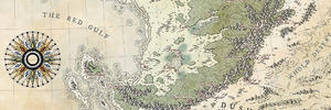
I decided to mix two of my passion, cartography and antiquity, and try to make a map of Ithaca according to Homer's Illiad and Odyssey. Odysseus and Telemachus sometimes talk about landmarks and main cities, I used the V. Bérard's comments to create that map (considering that today's Ithaca is Homer's Ithaca, that not really is sure). This could be considered as a topographic map as it's the only feature represented. I didn't want to overload it, but I must admit that Ithaca is not as rocky and mountainous as my map represents it (let's say it's because of geological evolution...).
I also made the choice to name places in french, that's because I prefer french traduction instead of english ones (that's totally personal of course) and because I didn't want to push as far as writing down everything in ancient greek.
Comments are welcome!
Ithaque.jpg
Nice map! Good drawing but I would have loved to see a colored version.
Nice work on this, particularly the linework to depict relief.
My Fantasy maps : http://www.cartographersguild.com/al...p?albumid=4205
Website: http://francoisgueydon.jimdo.com/fantasy/
Beau boulot ! There's an atlas flavor to your map that I like a lot !
Thanks for your comments!
Ilanthar : I'd like to make a coloured version as well, but to create proper shading, I think using a graphic tablet is much smoother, but I don't have one yet...
Francissimo : Thanks a lot, I always enjoy drawing relief
thomrey : That's what I was aiming for, although I'm not really pleased with the sea, grey shades are too messy and the scanner really enhanced those messy parts
Very nice map!
Again, I like a lot the way you managed shading. Very effective and subtle.
What is the size of the paper sheet?
Thanks AzurePlanet. For now, I only use A4 paper (21x29.7cm) mainly to create something quickly and keep my motivation.
Why not selecting the water only, copy and paste it into a new layer and then play with light and contrast ? You can even erase it partially to get something more gradient-y.Originally Posted by BlindBlake

That's a good idea, I see if I can get it working, thanks for the tip.
 Posting Permissions