Page 7 of 8 FirstFirst ... 345678 LastLast
Results 61 to 70 of 80

Thread: [Award Winner] Creating Realistic Coastlines

  1. #61
    Guild Artisan Facebook Connected Robulous's Avatar
    Join Date
    Aug 2011
    Location
    London, UK
    Posts
    596

    Default

    Apologies for reviving an ancient thread but I use the Ocean Ripple filter in Photoshop CS6 for roughening up edges, a setting of 9/4 does the trick.

    Untitled.png

  2. #62
    Administrator waldronate's Avatar
    Join Date
    Mar 2007
    Location
    The High Desert
    Posts
    3,610

    Default

    It's a worthwhile ancient thread to bring up once in a while. As you point out, Robulous, a similar effect can be achieved with a displacement filter and a suitable displacement map.

    One point about Old Guy's technique that I find useful is that the amount of blur used before thresholding effectively controls the size of the larger detail features added. Thus, one pass through with a moderate blur such as 2 or 3 followed by another pass with a smaller blur will give a more detailed coastline (subject to image resolution, of course). The two-pass technique also helps to reduce the appearance of sameness that otherwise reduces the visual appeal of the technique. It's the first two levels of a fractal, effectively.

    Blur2.gif Blur1.gif
    2-pixel blur ........................................ 1-pixel detail added to 2-pixel blur

  3. #63
    Guild Member Runninghead's Avatar
    Join Date
    Oct 2016
    Location
    Earth
    Posts
    87

    Default

    In case anyone's been playing with this bit of the process, I've had good results adding rivers in Photoshop (without Wilbur) using a layer of Difference Clouds and playing with Blend Mode. I'd love to write up a tutorial. How does one submit tutorials for Award consideration here?
    I also have a Photoshop action that instantly creates a map from any shape, clouds, sea and all- it's a lot of fun!
    (I appreciate there's more to cartography than just making a cool looking map, btw)

  4. #64

    Default

    Every tutorial submitted to the Guild is eligible for the Award. I'm not sure how much people use the Rate Thread feature any more, but I think that's the means used to preselect which tutorials are considered for an Award. It used to be, anyway; I haven't been keeping up with current events around here very well.
    Bryan Ray, visual effects artist
    http://www.bryanray.name

  5. #65

    Default

    Thank you for the thread and to the people that posted for "gimp". Apparently, there really is more than on way to skin a cat!

  6. #66

    Default

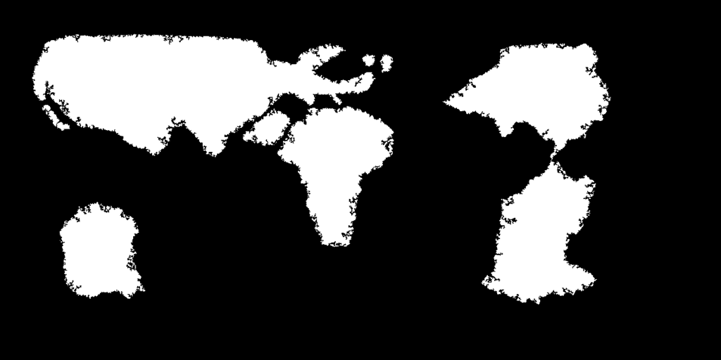
    So, I tried this technique with my world, and I feel the coastlines came out too prominent. They look kind of "crumbly," in my opinion; at least, compared to what you'd see on a map of our world.


    Incidentally, if you're wondering why the coastlines are somewhat inconsistent, it's mainly because I broke apart my map so that I could apply the technique differently to different areas. Just FYI.

  7. #67
    Guild Journeyer Facebook Connected Rongar's Avatar
    Join Date
    Nov 2009
    Location
    Germany
    Posts
    170

    Default

    Quote Originally Posted by Mysterious Mapmaker XXIII View Post
    So, I tried this technique with my world, and I feel the coastlines came out too prominent. They look kind of "crumbly," in my opinion; at least, compared to what you'd see on a map of our world.


    Incidentally, if you're wondering why the coastlines are somewhat inconsistent, it's mainly because I broke apart my map so that I could apply the technique differently to different areas. Just FYI.
    You may have to fiddle with the settings for both, the Gaussian blur and Threshold to get the desired results. It's very dependent of the size/resolution of your map. It also helps to repeat the process with different settings. I took your picture, loaded it into GIMP and applied the following:

    HSV noise (1, 0, 0, 255)
    Fade HSV noise (darken only)
    Gaussian Blur (5)
    Threshold (168 )

    and this is the result, a simplified, less crumbly and therefor more believable coastline, for continents at least.

    Less Crumbly Coasts.jpg

    If this was going to be the land shape for a regional map or an island, I would run the process again to get a more distinctive coastline, but for a world map I'd say this is fine.
    Last edited by Rongar; 02-18-2017 at 04:41 AM.

  8. #68
    Administrator waldronate's Avatar
    Join Date
    Mar 2007
    Location
    The High Desert
    Posts
    3,610

    Default

    The short answer is that real coastlines are multifractal rather than monofractal. For discussion purposes, that means that coastlines have smoother parts and crinklier parts. This technique tends toward the monofractal due to its use of uncorrelated noise. A way to get around this is to do a few versions of the coastlines with different amounts of noise and blur (or use the same noise and blur, but do it at 1/2, 1/4, 1/8, 1/16 scale followed by resize to original resolution) and then blend those versions together manually to get your final result. The manual process gives you good control over there the smooth parts are and exactly how smooth they are.

  9. #69

    Default

    Quote Originally Posted by Rongar View Post
    You may have to fiddle with the settings for both, the Gaussian blur and Threshold to get the desired results. It's very dependent of the size/resolution of your map. It also helps to repeat the process with different settings. I took your picture, loaded it into GIMP and applied the following:

    HSV noise (1, 0, 0, 255)
    Fade HSV noise (darken only)
    Gaussian Blur (5)
    Threshold (168 )

    and this is the result, a simplified, less crumbly and therefor more believable coastline, for continents at least.

    Less Crumbly Coasts.jpg

    If this was going to be the land shape for a regional map or an island, I would run the process again to get a more distinctive coastline, but for a world map I'd say this is fine.
    I figured it had something to do with the size of my map; the various continents definitely take up less pixels than the example shapes in the tutorial.

    Quote Originally Posted by waldronate View Post
    The short answer is that real coastlines are multifractal rather than monofractal. For discussion purposes, that means that coastlines have smoother parts and crinklier parts. This technique tends toward the monofractal due to its use of uncorrelated noise. A way to get around this is to do a few versions of the coastlines with different amounts of noise and blur (or use the same noise and blur, but do it at 1/2, 1/4, 1/8, 1/16 scale followed by resize to original resolution) and then blend those versions together manually to get your final result. The manual process gives you good control over there the smooth parts are and exactly how smooth they are.
    Interesting. I suppose the question now is which parts should be smooth, and which should be not-so-smooth. Any clues there?

  10. #70
    Administrator waldronate's Avatar
    Join Date
    Mar 2007
    Location
    The High Desert
    Posts
    3,610

    Default

    The only advice that I can give you about which parts should be smoother and which crinklier is that (here on Earth, at least) it's entirely a product of natural forces such as tectonics, erosion, and sea level. How things appear on your map is further complicated by scale because very crinkly details in areas may disappear, while what would be relatively smooth areas locally might have significant detail when zoomed out.

Page 7 of 8 FirstFirst ... 345678 LastLast

Posting Permissions

  • You may not post new threads
  • You may not post replies
  • You may not post attachments
  • You may not edit your posts
  •