Reply With Quote

I really like the mists in this map and the small flocks of birds add some nice details.
Only thing I can think of to improve the map would be to add a border to the map. It would help to frame the image.


Id like feedback on this.jpg
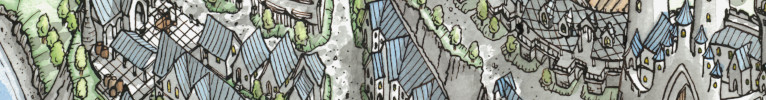
I would really appreciate some feedback on this. I dont know how popular inkarnate is but I find that you can do some pretty cool stuff if you use everything right.
This is the second version of this map, I have already gotten some feedback on it in other areas on the internet.
If someone can tell me how to get the effect of perspective im trying to put across here, that would be awesome. For context, the mountains are all relatively similar in size, but I tried to play with the perspective, changing the angle at which the land is viewed.
Thanks for your feedback
Angus950
I really like the mists in this map and the small flocks of birds add some nice details.
Only thing I can think of to improve the map would be to add a border to the map. It would help to frame the image.
Hi Angus, I like the map. It's nice and simple and all the elements come together well.
I'm terms of creating perspective, I assume you mean that you want it to look kind of like you're hovering in the sky looking over this region. One thing you could try is to add a slight haze that increases the higher up the map you go. On earth, since there is atmosphere, the further away an object is the more hazy it appears. It's one of the ways we subcontiously gage distances of far away objects. It's not something I've tried before but it could create an interesting look.
View my map and asset packs on CartographyAssets or DrivethruRPG. Support my work on Patreon. Take a look at my work on my Website or Instagram.
Good looking map, even though it's Inkarnate - personally, am not a fan of map making programs, preferring standard graphics applications, but that's just me, not a judgment on your choice.
True perspective mapping requires using vanishing points and horizons, even if only implied. This basically means that things get smaller the further away from the viewers perspective. If your mapping program allows you to rescale your map elements like your mountains and trees, you might effectively achieve implied perspective - it's not easy though, and you might not achieve it perfectly. The only map I have that qualifies as implied perspective was a hand-drawn map, so much easier to achieve than using software only, (I use a vector drawing program, Xara Designer Pro, that easily rescales objects) though I didn't use actual perspective, just implied. This was my November 2007 winning entry for a monthly challenge here - create Old West Map Objects, which I did, and this was a map created using those objects...
GP
superstition.jpg
Gamer Printshop Publishing, Starfinder RPG modules and supplements, Map Products, Map Symbol Sets and Map Making Tutorial Guide
DrivethruRPG store
Artstation Gallery - Maps and 3D illustrations
Wow, thats really cool, love the rough style. And thank you for your feedback. I am able to resize and even upload my own assets if needs be. I'll see if I can make another map with the effects you had in yours. Thanks for your help!Originally Posted by Gamerprinter

Nice, though those high cliffs around the whole coastline does look rather odd.
Thanks for your feedback, but I have a question for you, how do you have a link to an album of your finished maps? Id love to have something like that on my comments.