Ok! I have now finished drawing. I have included a picture of it below but I will still need to scan the map in and also post an image that only contains the areas within my boundaries since, for the sake of the image, I extended beyond my boundaries on all sides.
85055900_649649279106108_7428544335303409664_n.jpg
This looks great, Arimel, and really interesting, both for the style and land itself !
For the purposes of including it into the big slippy maps I can cut out the borders of images providing that you stuck to the original borders set out by J.E. But if you have a large label that crosses the border then it will also get cut on the border.
Thank you MistyBeee!Originally Posted by MistyBeee

The general layout of the country itself has stuck to the borders given but I will need to do some editing to either remove or move the actual territory names. We shall see which seems easiest for me to do when that time comes!
On the topic of scanning though, what ppi (that is the correct unit, right?) works best. If I remember correctly, my options are 100, 200, 300, 400, 600. I tend to scan at 400 but I dont want it to be too large of an image!
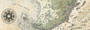
Looks like I am doing this project in monthly jumps! Here we go again. I have clipped the names of the places from the image and filled in the empty spaces. It should align with the borders of the part in the master map (fingers crossed). Beyond that though I think the section is done!
Area 57 cut-out.png
Wow. This is the first image I have posted in a month... I have got to get some of my other posts up!
That's looking cool
Artstation - | - Buy Me a Kofi
And, as a neighbor, usefulGreat work !


Nice to see you're going on !
Thank you everyone! I have gone forward with a test of color on my paper version of the map. Colored pencils may not be a favored medium here on the guild but it is the best I can do here! Let me know what you think!
area 57 1.jpg
area 57 2.jpg
 Posting Permissions


 Reply With Quote