Page 36 of 45 FirstFirst ... 26323334353637383940 ... LastLast
Results 351 to 360 of 658

Thread: [Award Winner] Using GIMP to Create an Artistic Regional RPG Map

Hybrid View

Previous Post Previous Post   Next Post Next Post
  1. #1

    Default

    I'm not sure how Gimp's color chooser operates, but that means a color that is 50% value and 0% saturation. Or in typical RGB colors: 128,128,128.

    Any time all three numbers in RGB are the same, the resulting color will be some level of grey, black (0,0,0) or white (255,255,255). 128 is half of 255, so that's 50% value.
    Bryan Ray, visual effects artist
    http://www.bryanray.name

  2. #2
    Guild Apprentice crackerjake's Avatar
    Join Date
    Aug 2008
    Location
    Lafayette, IN
    Posts
    45

    Default

    I'm not finding a simple RGB scale, they're three other slides that change value when I put the RGB at 128, denying me a grey. I hate having to ask how to do something so simple, but could someone walk me through this?

  3. #3
    Guild Artisan geamon's Avatar
    Join Date
    May 2009
    Location
    Bronx, NY
    Posts
    616

    Default

    Midgardsormr is right. Just click once on the Foreground color and set your values like the image bellow and you will have "50% grey". You can again make the layer using the foreground color that you know have set or use the fill tool.


    Also for the most part most questions you are asking are general software use related issues. We are more then happy to help and answer the questions. But I like someone who tries and teach themselves as well. Here is GIMP's tutorials on the use of the software may wanna refer to it to learn the software as your trying out mapping. I personal referred to it when I wasn't sure on the use of one of the software's tools and more often then not it answered my questions.
    Cheers, Julien

    Battlemaps, Town Maps, Tutorials.
    All my maps and content are posted and published under this Creative Commons License. Click Here for information on licensing.

  4. #4
    Guild Apprentice crackerjake's Avatar
    Join Date
    Aug 2008
    Location
    Lafayette, IN
    Posts
    45

    Default

    I didn't even know those existed, I'll give them a read through, thanks, you've been very helpful.
    Last edited by crackerjake; 11-07-2010 at 09:10 PM.

  5. #5

    Default

    Hi, having 2 areas of difficulty with my rivers which I hope someone can help me. When I draw my rivers from the mountains they vanish when they reach the dirt area at the coast. Also I need idiot-level guidance re: how to bevel them.

  6. #6
    Guild Novice
    Join Date
    Mar 2010
    Location
    Nevada
    Posts
    5

    Default

    RobA,

    While I have you...perhaps you can help with another question. I have been following along with your 4-part tutorial on land making and I am stuck on a section in part 2; the Mountains area...as follows:
    Now we want to create a heightfield from this. The easiest way I have found to do this is to copy the current visible image (B|Edit->Copy Visible)/B then paste it (CTRL-V) to
    a floating selection. Click the New Layer button to get it on its own layer rather than a
    floating layer. Now stretch the colour range out (B|Color->Auto->Normalize)/B:
    My question: Are you saying to copy the image to a new file and then pasting from the new file back into the original one?

    Thanks!

    Viper
    Last edited by Viper; 12-03-2010 at 12:01 AM.

  7. #7

    Default

    Quote Originally Posted by Viper View Post
    RobA,

    While I have you...perhaps you can help with another question. I have been following along with your 4-part tutorial on land making and I am stuck on a section in part 2; the Mountains area...as follows:
    My question: Are you saying to copy the image to a new file and then pasting from the new file back into the original one?

    Thanks!

    Viper
    Viper-

    (Moved the question)

    Nope - Copy Visible will flatten all the layers into a copy buffer. Just paste this (edit->paste) to get a new floating selection and anchor it to make it a "real" layer.

    No new image.

    -Rob A>

  8. #8
    Guild Novice
    Join Date
    Mar 2010
    Location
    Nevada
    Posts
    5

    Default

    RobA,

    That's what I thought you meant, but the extra letters confused me at first. I am assuming it must have been html code that was in part of the tutorial.

    Thanks

    Viper

  9. #9

    Default

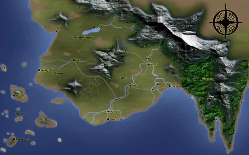
    Hello,

    My first post here. I know it has been said many times in the thread, but this is a really excellent tutorial.
    This was my first attempt at using GIMP and I am happy with the result.

    The mountains are a bit off, and I did some hand painting for a swamp because I could not get the textured layers approach of the forests and mountains to look 'swampish' enough.

    Still, thanks for the excellent introduction to the software, and mapping.


  10. #10
    Guild Master Facebook Connected jtougas's Avatar
    Join Date
    Sep 2010
    Location
    Wales Massachusetts
    Posts
    2,813
    Blog Entries
    27

    Default

    Very Nice !! if your looking for a bit of feedback the tops of your mountains are pretty sharp. But all in all a excellent job
    I am the breath of Dragons...The Song of Mountains...The Stories of Rivers....The Heart of Cities.... I am A Cartographer....

    Finished Maps
    Kingdom Of Shendenflar Campaign Setting (WIP)

    Everything I post is free for use and redistribution under the Creative Commons Attribution-Noncommercial-Share Alike 3.0 licence, except where noted otherwise in the thread.

Page 36 of 45 FirstFirst ... 26323334353637383940 ... LastLast

Posting Permissions

  • You may not post new threads
  • You may not post replies
  • You may not post attachments
  • You may not edit your posts
  •