Color indeed could work, but it's something I suspect might happen maybe on some copy in some rather distant futureOriginally Posted by Ilanthar


Color indeed could work, but it's something I suspect might happen maybe on some copy in some rather distant future
Oh wow! I'm in awe of and more than a little in love with your amazing hand-drawn depiction of mountains!
Mapping blog, my maps mixed with the maps of many other people: https://oldearthmapping.tumblr.com
Avatar by the fantastic Brian Farrar: https://artblaster.tumblr.com
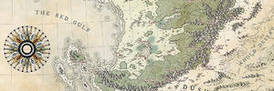
And so I've finished the mountains, it's time now for rivers and towns.
_MG_8942.jpg
And a bit of an update with rivers and towns. I was very, very unhappy with the rivers — I thought they were way too thick, to the point where I actually wanted to start it all over again — but my friend suggested thickening the main rivers and it actually worked really well. I'm relatively happy about the result now (but mmy next map will have thinner rivers anyway).
_MG_8946.jpg


To think all of this was made by hand, really impressive ! I love the lettering and the crest, so clean.
I always admire people drawing such detail by hand - I always worry about messing it up!
It is impressive ! At first I thought the map would be a bit barren without forests but I was so wrong ...
I didn't have much time to work on it due to personal issues, but I hope the swirly text changes enough of the map:
_MG_9255.jpg
Also, I already have another project planned, this time it will be a continent map - do you have any resources on drawing map projections by hand?
This map is looking so good. Great techique for mountans, realistic landforms, beautiful lettering and a true feeling of a 1600's century map. Hard to say what could be better. Some more rivers in the flat areas perhaps?
The projections were calculated and drawn by hand somehow before computers, and I think that requires a lot of knowledge and many calculations. But if you don't need to draw the map in many projections, an easy way is to copy a grid from another map. This is what I did with my map of Magran (still ongoing project, wip here).
- Find an atlas that is larger than the size of paper in your map
- Select a map with the same scale than your map, and from the same latitude as the place in your map (longitudes doesn't matter, naturally, and neither the hemisphere.)
- Place your map on top of the atlas's map. North to north if the maps are on the same hemisphere and upside down if they are on different hemispheres.
- Mark the locations of the lines of latitude and longitude in the sides of your map with pencil.
- For longitudes, the points can be just connected with a ruler (in most projections).
- For latitudes, I measured the distance of the line from the side of the paper in places where they crossed the longitudes and marked them on the map. Then I connected the points to one line with a flexible curve.
- If you like, write labels for the lines in the map. Longitudes can be anything you like, latitudes the same as in the atlas.
The result is a grid of a real projection, exact as in the surface of our earth. Of course, it's only a mock projection, but it looks good. If the depicted area is large, you have to take different distortions into considerstion to keep it realistic.
I've found old cartography textbooks to be most helpful. For example one from the 1950's, Elements of Cartography, they teach in them how to make good maps by hand. There are also information about calculating the projections, if interested.
I hope this helps!
www.orbigraphia.com - More maps also in instagram @orbigraphia
Thanks a lot, Meton, I bet it will be really useful for me soon.
I started working on making the sea less empty — but I think I messed up with the name in fraktur, it's too heavy and too important because of that. But, well, it looked good in pencil and it's too late now.
_MG_9516.jpg
 Posting Permissions

 Reply With Quote