Page 1 of 2 12 LastLast
Results 1 to 10 of 16

Thread: WIP Conworld, w/ Geology!

  1. #1

    Wip WIP Conworld, w/ Geology!

    Hello, everyone!

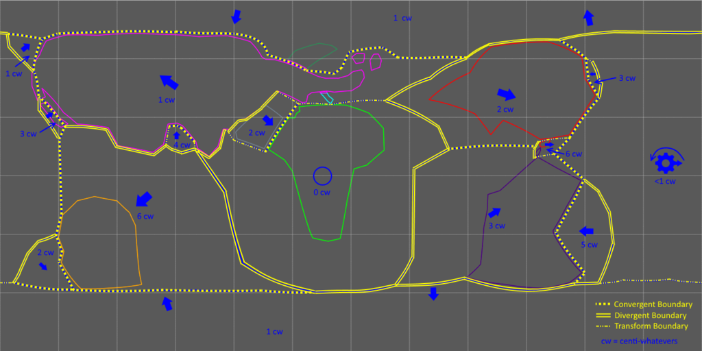
    I've been working on a conworld for quite a while now. Right now, I'm working on the geology. It's been slow-going, but I've finally managed to complete a map of my world's plate tectonics. I just wanted to show this off and ask if there are any clear problems with my plate tectonics.


    Centi-whatevers are close to centimeters. The gear with an arrow indicates that the plate is rotating more than it's moving.

  2. #2

    Default

    For me there are. I wouldn't have even noticed this an hour ago (I had all the knowledge, but didn't put it together until just then lol), but plat tectonics are really easy I think now...

    Starting with the plates is a bad idea, because where the plates break up are determined by the Land masses...
    So start with a Pangea. Roughly the center of this land mass will be your Mid-atlantic ridge. Everything to the Left of this will be moving left and everything to the right will be moving right.
    The next step is the western and eastern edges of the pangeo land mass will be subduction zones and they will have mountains/islands and or volcanoes.
    Horizontally, plates move awat from the equater/pole based on which they are closer to.
    And lastly, I don't have any clue why, but maybe someone with more physics knowledge can say... I think it is likely due to their just being more stress in that location, there are more rifts horizontally, closer to the main rift (the mid atlantic rift)

    Some plates move counter to the above, but that is because they are being pushed/pulled by larger plates rather than that being their actual overall movement. For example, the Nazca Plate is moving counter to this because it rifted with the Pacific Plate, but the process to subduct it are already in process and the convection currents are right under it the rift between it and Pacific Plate, pulling/pushing it in the opposite direction you'd thing which also creates divergent boundary where there aught not be one.

    Using these points I think it is fairly clear that there are some errors in your plate map, at least in my opinion.

  3. #3
    Banned User
    Join Date
    Jul 2014
    Location
    Traverse City, Michigan, USA
    Posts
    2,547

    Default

    Quote Originally Posted by Durakken View Post
    ...And lastly, I don't have any clue why, but maybe someone with more physics knowledge can say... I think it is likely due to their just being more stress in that location, there are more rifts horizontally, closer to the main rift (the mid atlantic rift)....
    If you are talking about the transform faults that are perpendicular to the mid-Atlantic Ridge line, those occur because the divergent boundary is trying to spread at the same rate all along the length, but on a sphere that's not so easy. To see why, lay two sheets of paper on a globe with the edges side by side and then holding the corners together, try to spread the two pieces of paper apart. You'll see that in order to do that, they would have to bow up and spread much faster at the center than at the ends. Since that can't happen with the plate movement, the plates fragment along transform faults to accommodate the differential rates of spreading.

  4. #4

    Default

    I was actually referring to 2 things at once accidentally, my bad.
    If You look at the North American Plate it should be broke vertically around where Alaska is and the Eurasian Plate should also be snapped in 2. My guess is that either my reasoning is wrong in why they should likely be broken or it has something to do with the reason the other 2 vertical convection zone rift areas are broken from top to bottom is because the 1 is the main 1 and the other other is the one always getting the whole force of that pushing on it, thus snapping it while allowing the other 2 to be fine, or rather 1 snapping only on the southern side and the other only snapping on the northern side.

    The other things I was point out is that as you move closer to the main break the more smaller breaks and the more likely there is horizontal break than a vertical break... Or something like this. And what you said seems to explain this. So yay thanks.

  5. #5
    Guild Artisan Pixie's Avatar
    Join Date
    Jan 2014
    Location
    Lisbon
    Posts
    939

    Default

    There aren't any obvious fails in your tectonics, at least not to my eye, Mysterious Mapmaker XXIII. Congrats on what you've accomplished!
    But, the whole thing seems very simple. By this I mean that it has very few plates and that it resembles Earth a lot (the large pacific ocean and the african continent!). Not necessarily bad things, but if you managed this much, I think you can aim at something even more original and still believable.

    A couple of questions, if you don't mind me asking...
    1. Did you do this with G.Plates? If not, do you know the program?
    2. Have you ever seen this map and text? I think it's an awesome source.

  6. #6

    Default

    Quote Originally Posted by Pixie View Post
    1. Did you do this with G.Plates? If not, do you know the program?
    Cool tool, I'd never heard of it before so I went and looked at it, unfortunately I don't think it's very helpful overall if someone is using it as it seems to assume you know the end and beginning point and doesn't apply physics which means at best you're getting a tool that tells you very little and becomes more of a glorified animation program than anything else. At least that is what it looks like to me after a few hours of looking into it and experimenting with it.

  7. #7
    Guild Artisan Pixie's Avatar
    Join Date
    Jan 2014
    Location
    Lisbon
    Posts
    939

    Default

    It's just an animation tool but very useful, even for the scientific community - I've seen papers usinf or refering to the program. For us, conworld builders, the main use is the fact that it allows to correctly evaluate the movement of the plates that we imagine.

    Have a look at this:
    http://www.cartographersguild.com/sh...ad.php?t=27652

  8. #8

    Default

    Quote Originally Posted by Pixie View Post
    It's just an animation tool but very useful, even for the scientific community - I've seen papers usinf or refering to the program. For us, conworld builders, the main use is the fact that it allows to correctly evaluate the movement of the plates that we imagine.
    The thing is, if you're creating Tectonic plates you want it to be realistic. So randomly creating plates and then randomly putting them together and then animating them isn't accomplishing anything other than a false sense of accomplishment. So that main use isn't actually there.

    Although there does seem to be some functionality somewhere in it that can be used to create a more realistic output.. It's just laid under terms and GUI that is poorly designed and labeled for anyone that isn't a geologist. I'm not saying it isn't useful to scientists, but that is because they already know generally the output is going to represent real physics and all they are doing is adjusting properties that can be extrapolated from the real world. The sad thing is that it could be midified, probably to do what is needed which is to basically allow someone to lay down a main rift line on a single structure and then extrapolate all the stress point breaks that would naturally occur as a result. The gui for this really could be minimal and the changes would likely benefit the program overall, but the likelihood that any of the developers would make those additions/alterations is probably minimal so I guess the next best thing is to do it by hand or find settings that can aproximate realistic physics.

  9. #9

    Default

    @Durakken: I'm having a little trouble understanding your complaints. What do you mean by "Alaska"? By "vertical convection zone rift areas"?

    @Pixie: Yes, I did in fact use GPlates; mainly, it was to create the continents. I also did it for the basic outlines of the plates. However, to determine the nature of the boundaries, as well as to draw in the speeds and directions of the plates, I used paint.net.

    And no, I had not seen your link before. Maybe I'll check it out some time?

  10. #10

    Default

    Quote Originally Posted by Mysterious Mapmaker XXIII View Post
    @Durakken: I'm having a little trouble understanding your complaints. What do you mean by "Alaska"? By "vertical convection zone rift areas"?
    You know, Alaska, the state...

    There are roughly 6 convection zones... just because that's how it works. They roughly point in the direction of the side of a dice. If you look at where there is large vertical, as in going from south to north pole, rifts, they are over where the convection zones are roughly. There are 2 that extend roughly the entire length of the planet and 2 (one sorta does but not quite) that only extend to roughly the equatorial zones.

Page 1 of 2 12 LastLast

Posting Permissions

  • You may not post new threads
  • You may not post replies
  • You may not post attachments
  • You may not edit your posts
  •