Reply With Quote


Thank YOU ! The map is gorgeous !


Hello Cartographers,
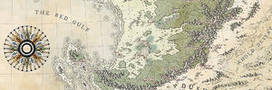
Here is a continent map I worked on last night. I'm continually trying to make my mountian ranges more realistic, considering plate tectonics, and using GIMP and Wilbur as my software of choice. Please criticize away, and if you can suggest a thread that explains "how to make more realistic tectonic features using GIMP/Wilbur," I'd be grateful to read it.
Azaria.jpg
Thank you!
Peter
Thank YOU ! The map is gorgeous !
Yup, very nice render! Your skills with Wilbur (& probably Gimp too) are clearly better than mine, so not much more to say.
Hi Peter, really nice work on this so far! The hills and mountain ranges look very good. I don't know about any tutorials regarding plate tectonics specific to GIMP/Wilbur, but I know Pixie and Charerg have both been working on large world-building projects involving plate tectonics. If you haven't already done so, it would be worth your while to check out their world-building threads. Look forward to watching what you come up with.
Cheers,
-Arsheesh
Hi there Peter Toth,
I had a first look at your map / picture with my smallish screen phone and it seemed great, then kind of made a mental note to come and write a proper review/advice, but never really got round to it until now. I'm not a wilbur expert, mind you, nor a geologist, so you can/should take everything I write as humble opinions only.
But, alas, on to opinions:
(1) the overall shape and location of major mountain ranges is sound. Looks like a continental platform with a subduction boundary to its north. The eastern mountains are older, perhaps a previous tectonic boundary now replaced by a back-arc basin, which explains the eastern most, japan-like, large islands.
(2) the job with wilbur seems well done to my eyes. I have no idea how long you "wilbured" this back and forth, but I like the erosion. I like it a little more than the overall riverine system.
(3) wilbur has one problem, though, that you didn't care for or tried to avoid at all - it doesn't drop sediment. You should have flood plains somewhere, and in general much more flat areas, and the lowlands of those rivers should be well visible, large and featureless, instead of having those sea-level river canyons, filled with eater or so many inner depressions filled-with-water-but-only-to-a-point.
This is really by biggest criticism. You see, old continents (this one can't be young) had enough time to fill their basins with sediment, those filled basins are areas where rivers slow down and meander, with smallish mountains/hills around them and no longer depressions. Those lakes seem like random recent depressions in the middle of ancient crust, quite the opposite of what one would expect.
(4) I hope this is just a middle step towards a finished map because it lacks actual cartography - that's a visual identity, carefuly place information and a purpose (even if fictitious, we normally do fictitious around here)
(5) to end in a good note, perhaps the strongest point... the northern range is quite good, the mountains further from the coast could be more eroded (less tall, some kind of plateaus in between), but the majority is spot on! 99% of wilbur users will be jealous of those.
 Posting Permissions