Page 1 of 6 12345 ... LastLast
Results 1 to 10 of 58

Thread: Feb / Mar '18 Light Challenge: Castleton Island

  1. #1
    Guild Adept Tonquani's Avatar
    Join Date
    Nov 2017
    Location
    Cumbria, UK
    Posts
    400

    Default Feb / Mar '18 Light Challenge: Castleton Island

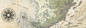
    So the idea here is for a nautical chart - the sort that would be used for fishing, close in shore marine navigation etc.

    Castleton Island is somewhere in the Caribbean and is approximately 10-20 miles long.

    ### Latest WIP ###
    castleton island.png

  2. #2
    Guild Master Falconius's Avatar
    Join Date
    Jul 2013
    Location
    Israel
    Posts
    2,727

    Default

    I like the idea. The sea shelfs look wonderful, and the islands fit perfectly.

  3. #3
    Guild Master Facebook Connected - JO -'s Avatar
    Join Date
    May 2016
    Location
    Geneva, Switzerland
    Posts
    2,871

    Default

    Very nice idea and good choice of colors !
    If I may risk a comment : the dropped shadows on the different surfaces of blue is disturbing, I think... Is it intended or it's just a mistake ?

  4. #4
    Guild Adept Tonquani's Avatar
    Join Date
    Nov 2017
    Location
    Cumbria, UK
    Posts
    400

    Default

    Quote Originally Posted by - JO - View Post
    Very nice idea and good choice of colors !
    If I may risk a comment : the dropped shadows on the different surfaces of blue is disturbing, I think... Is it intended or it's just a mistake ?
    Indeed, all comments are more than welcome.

    I was trying to portray increasing depth with the lighter colours, however, like you, I also don't really like it. I may try a blurred version to see how it comes out......

    T

  5. #5
    Guild Master Facebook Connected - JO -'s Avatar
    Join Date
    May 2016
    Location
    Geneva, Switzerland
    Posts
    2,871

    Default

    Quote Originally Posted by Tonquani View Post
    Indeed, all comments are more than welcome.

    I was trying to portray increasing depth with the lighter colours, however, like you, I also don't really like it. I may try a blurred version to see how it comes out......

    T
    I think if you reverse your colors you will obtain what you’re looking for. Usually on marine charts, the lighter colors stands for the less deep waters (and the dark blue shows deepest waters) so usually the white is near the coasts and the dark blue is at large...

  6. #6
    Community Leader Bogie's Avatar
    Join Date
    Nov 2011
    Location
    Maine, USA
    Posts
    7,664

    Default

    Good start, interesting version of the map. And speaking from total lack of knowledge, I agree with Jo on the color use.

  7. #7

    Default

    Here are some of the resources I used for my nautical chart inspired map a few months back:
    https://www.cartographersguild.com/s...ad.php?t=38691

    Hope they're useful!

  8. #8
    Professional Artist ThomasR's Avatar
    Join Date
    Nov 2015
    Location
    Angers, France
    Posts
    4,154

    Default

    If you're aiming to this, that would be perfect

  9. #9
    Guild Master Facebook Connected - JO -'s Avatar
    Join Date
    May 2016
    Location
    Geneva, Switzerland
    Posts
    2,871

    Default

    Quote Originally Posted by Daistallia View Post
    Here are some of the resources I used for my nautical chart inspired map a few months back:
    https://www.cartographersguild.com/s...ad.php?t=38691

    Hope they're useful!
    You’re right.... I don’t know what I was thinking : the white is the deepest waters on nautical charts...
    Sorry

  10. #10
    Guild Adept Tonquani's Avatar
    Join Date
    Nov 2017
    Location
    Cumbria, UK
    Posts
    400

    Default

    Quote Originally Posted by Daistallia View Post
    Here are some of the resources I used for my nautical chart inspired map a few months back:
    https://www.cartographersguild.com/s...ad.php?t=38691

    Hope they're useful!
    Thanks Daistallia, they are, very much! I was pretty much limited to an old UK Admiralty paper chart that I had at home. This gives me a few more ideas...

    Quote Originally Posted by ThomasR View Post
    If you're aiming to this, that would be perfect
    Ooooh, those are really nice. No, I wasn't really thinking of that, but you've opened a whole new can of worms now...

    Quote Originally Posted by - JO - View Post
    You’re right.... I don’t know what I was thinking : the white is the deepest waters on nautical charts...
    Sorry
    That's alright, when I first started looking into them, it also puzzled me a bit. I think it's got to do with focussing attention on the coastal waters where boats are more likely to run aground/ need to navigate more carefully...

Page 1 of 6 12345 ... LastLast

Posting Permissions

  • You may not post new threads
  • You may not post replies
  • You may not post attachments
  • You may not edit your posts
  •