Results 1 to 9 of 9

Thread: World fantasy map

  1. #1

    Default World fantasy map

    Hello,

    I come back with a new project. I want to extand my old map for a world. In first place, I work on a part of the world and now, I want to develop my world. So please find the blank map of Ityopis :

    Map entière.png

    To start on good way, please help me to improve my map.

    Thank you

  2. #2

    Default

    Those RL countries shapes are totally obvious and make the map look rather silly. You could do a lot better by using any of a number of different ways to generate random coastlines, such as shown in this tutorial.

    Also, if your map is intended to cover the surface of a spherical planet then you should set it's dimensions to a 2:1 ratio for width and height. This is because the distance (along sea level) from north pole to south pole is half the length of the equator.

  3. #3

    Default

    Outch ! Your critic is very hard to heard. Yes i use some known shape. It's the first step for me to work. But one part of the map is not a known shape. I draw this part a long time ago and this part can't be changed for a simple reason : I play with it.

    I try your tutorial and I find one for GIMP.

    Do you think it's better with this kind of shape ? I only do a part of the world to work the technical aspect.

    Corner SE.png

    For the size, it's really difficult to do a size 2:1 because the part below is 3600x3600 and it's the corner South-Est of the world. If I want keep the same size, I need to have a map [16000 / 17000] x [8000 / 8500]. My computer must be crash with this size. I think, i can work on the shape for the moment and cut my map in 2 or 4 to work on each part.

  4. #4

    Default

    Quote Originally Posted by Crotal View Post
    Outch ! Your critic is very hard to heard.
    My apologies if my words came across as harsh. Please understand that none of it was intended to be personal, nor malicious. That said though, this forum is a place for map designers to discuss their works and present criticism and advice so that we can become better at our craft. That's not possible without being honest about any flaws one perceives in someone else's maps. If you post your map here and ask for feedback, then you should be prepared that it might not be all positive.

    Quote Originally Posted by Crotal View Post
    Do you think it's better with this kind of shape ? I only do a part of the world to work the technical aspect.
    The coastline is improved from the previous picture.


    Quote Originally Posted by Crotal View Post
    For the size, it's really difficult to do a size 2:1 because the part below is 3600x3600 and it's the corner South-Est of the world. If I want keep the same size, I need to have a map [16000 / 17000] x [8000 / 8500]. My computer must be crash with this size. I think, i can work on the shape for the moment and cut my map in 2 or 4 to work on each part.
    Cutting a large map into smaller sections to work on is a useful technique in general. If you could arrange the landmasses so that each one is located on either the western or the eastern hemisphere, separated by ocean (except for those polar continents of course) then it would be quite easy to divide the map into two square parts. You can tell that you have this kind of arrangement if you can draw a vertical line at the center without crossing a landmass, and none of the landmasses are spanning over the left and right edges of the picture.

  5. #5

    Default

    Thank you for you reply ! I'm here to submit some comments and critics to the other members. It's not a problem for me. I want to have the better map as I can do so I need to hear what you say even if you don't like.

    Yes, the map above is a part of the first map. In fact, this is the shape of the map I use with my players. So I can't change a lot of things on it. For you, this part is acceptable ?

    I improve an other technic of ramdon costline for all the other part of the world. I need to cut them.

  6. #6

    Default

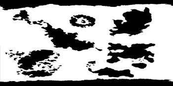
    My new shape for my world :
    Map entière - Copie.png

    I think it's better than my first one.
    I'm not sure for my artic and antartic because I want to have a sphere world in picture and I think the two corners don't get in touch when I world be spherical.

  7. #7
    Guild Expert johnvanvliet's Avatar
    Join Date
    Jul 2012
    Location
    N 42.39 W 83.44
    Posts
    1,091
    Blog Entries
    4

    Default

    that map looks to be in Mercator projection
    about 85 north to 85 south
    remapped to a simplecylindrical equal area projection
    my GDAL is down right now so used "G.ProjectorJ"
    --- java program ---
    http://www.giss.nasa.gov/tools/gprojector/

    With the north and south pole fixed ( used "resynthesizer" Gimp plugin from the git hub )
    https://github.com/bootchk/resynthesizer

    it should look like this 4096x2048 image


    the internet archive still has some old short tutorials i put together
    http://web.archive.org/web/201306251...p?f=21&t=16959
    and this one- on fixing a image
    http://web.archive.org/web/201306251...p?f=21&t=17002

    i was a bit "rude" and a bit angry when i wrote them so please do not pay attention to that
    Last edited by johnvanvliet; 10-24-2014 at 04:48 AM.

  8. #8

    Default

    For the moment, I'm not sure to use some tool to make my world strictly spherical. It's a fantasy world so I do what I want
    And this map is an hand drawn map style not a relalistic map.

    Please find my new update of my shape for my world :
    Map entière - Copie.png

  9. #9

    Default

    I come back with my color fantasy world.

    Image map.jpeg

Posting Permissions

  • You may not post new threads
  • You may not post replies
  • You may not post attachments
  • You may not edit your posts
  •