Hi Joe,
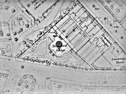
I have enhanced the posted image a bit to see it more clearly. I would also recommend looking at the national library of scotland's site which has a nice interface to a lot of old OS maps about that time. I had to do some research of something about 1885 and found a map there. They have the whole UK on OS maps of that time online. I'll see if I can edit in a link to it.
Seems to be marked as a church on this old map and all the subsequent ones to 1938. Is it a masonic lodge then ?
http://maps.nls.uk/view/101579898
Image posted credit:
Code:
1. Non-commercial, educational and private use of map images

You are welcome to use most images displayed on the Maps website for non-commercial, educational and private purposes under the terms of the Creative Commons Attribution-NonCommercial-ShareAlike (CC-BY-NC-SA) licence. This includes use in a free exhibition or lecture, or in a university thesis.

Use is conditional on provision of attribution. Please apply the credit line 'Reproduced with the permission of the National Library of Scotland' wherever you re-use map images. If you create derivative work, the documentation of your work must contain this attribution.

For online publications, we request that your attribution includes a link to our Map images website.


 Reply With Quote


