Reply With Quote
it looks not quite full planet
but about 80 north to 80 south in Mercator projection


I am trying to figure out the style for this world map that I am working on:
world map.jpg
Not sure what to go with and haven't seen a lot of full world maps that were done really nicely. Any suggestions?
- I want to stay away from symbolic single mountain and single tree pics as they would not fit in the full world map and I'd like to have some colour in there so if you have suggestions or examples I'd love em.
Here is a map that I recently did and is actually a part of this world and done in an old style map which I want to stay away from for the whole world map.
MapofNedreal.jpg
it looks not quite full planet
but about 80 north to 80 south in Mercator projection
--- 90 seconds to Midnight ---
--------
--- Penguin power!!! ---
What John said, even if it doesn't really answer the question.
I'm not sure exactly what you are looking for since there are plenty of nice maps on this site.
By symbols you mean brushes? It's often associated with an isometric perspective, seeing things at an angle.
You might be interested in top down views and caterpillar mountains.
https://www.cartographersguild.com/s...ad.php?t=33150
https://vignette.wikia.nocookie.net/...20120201174035
Yes thats what I was looking for - top down. Additionally, while I like to do mountains in isometric it seems inappropriate for a full world map, and also having single tress to represent forest, so I was looking for maps that are of an entire world and usually I find regional ones.Originally Posted by Azelor

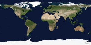
I don't really do many maps, this is the first full world map I ever did and the other smaller map is the first regional map I ever finished. I am not sure what 80 by 80 means in terms of Mercator projection? What should I do to make it full world?
Hi as to 80 North to 80 south
that was a educated guess without doing the MATH
with your image at 1200x675 and the look of the landmasses this really is 71 degrees North to 71 degrees South in Mercator projection
https://en.wikipedia.org/wiki/Mercator_projection
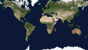
here is a reconcilable map
first one is in Simple Cylindrical projection ( 90 north to 90 south , and -180 West to +180 East )
and the same image remapped to 71 north / south ( 71 north to 71 south , and -180 West to +180 East )
Wikipedia has a GREAT Reference page
https://en.wikipedia.org/wiki/List_of_map_projections
.
--- 90 seconds to Midnight ---
--------
--- Penguin power!!! ---
The main difference between regional and world maps is not the style, it's the area shown by the map. They can have any style you want.
Also, to answer the thing about the incomplete map: it's because your poles are incomplete.
I know this because the landmasses at the poles are interrupted, unlike Antarctica but also different from Greenland.
Greenland ends before reaching the pole. The pole is water, not land.
Antarctica covers the whole south pole. The pole is ice.
But right now, your poles are water and ice at the same time. This is not possible unless the map is cropped.
Explained differently, the pole is a single dot. You can only have either land or water at a given place.
The problem is that most map projection shows this dot as a line but it's still just a dot when you look at the planet in 3d.
Last edited by Azélor; 09-26-2017 at 12:34 AM.
 Posting Permissions